|
|
|
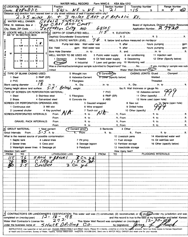
Specific Water Well Detail |
|
|
| Location Info | |||
| Owner: Swanson, Gerald | Status: Plugged | ||
| Location: T1S, R4W, Sec. 21, SW NE NE | County: Republic | ||
| Directions: from Republic, 2.25 mi N and 3 mi E | |||
| Latitude: 39.9554173 | Longitude: -97.7664277 | Datum NAD 27 | |
| Latitude: 39.9554274 | Longitude: -97.7667481 | Datum NAD 83 | |
| Longitude and latitude calculated by Survey from township-range-section-quarter calls. Only good to within the quarter call accuracy. | |||
| View well on interactive map | |||
| General Info | ||
| Well Depth: 115 ft. | Elevation: ft. | |
| Static Water Level: 76 ft. | Est. Yield: gpm. | |
| Comp. Date: 16-Dec-1998 | Well Use: Irrigation | |
| DWR Applic. #: 27420 | Other ID: | |
| Links | |
| No Wizard information available. | |
| View info from WIMAS Water Right Data base... | |
| Driller Info | ||
| Driller: Shuck Drilling Co. | License #: 272 | |
| Scanned Form | View scan |
| Casing Info | ||
|
Casing Type:
Diam: in. Casing height above land surface: in | ||
| Grout Info | ||
| Grout used: | From: to ft | |
| Source of Possible Contamination | ||
| Source: | ||
| Direction from well: | Distance: ft | |