|
|
|
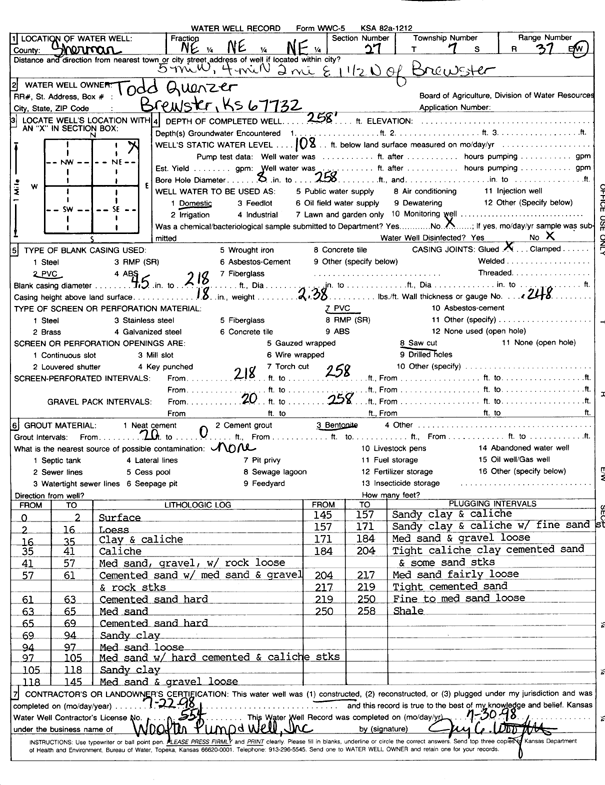
Specific Water Well Detail |
|
|
| Location Info | |||
| Owner: Quenzer, Todd | Status: Constructed | ||
| Location: T7S, R37W, Sec. 27, NE NE NE | County: Sherman | ||
| Directions: from Brewster, 5 mi W, 4 mi N, 2 mi E, and 0.5 mi N | |||
| Latitude: 39.4234879 | Longitude: -101.4284998 | Datum NAD 27 | |
| Latitude: 39.4234886 | Longitude: -101.4289419 | Datum NAD 83 | |
| Longitude and latitude calculated by Survey from township-range-section-quarter calls. Only good to within the quarter call accuracy. | |||
| View well on interactive map | |||
| General Info | ||
| Well Depth: 258 ft. | Elevation: ft. | |
| Static Water Level: 108 ft. | Est. Yield: gpm. | |
| Comp. Date: 22-Jul-1998 | Well Use: Domestic | |
| DWR Applic. #: | Other ID: | |
| Driller Info | ||
| Driller: Woofter Pump & Well, Inc. | License #: 554 | |
| Scanned Form | View scan |
|
Chemical Sample Submitted?:
Water Well disinfected?: | ||
| Casing Info | ||
| Casing Type:
Casing Joints: |
Diam: in. to ft | |
| Casing height above land surface: in
Casing Weight: lbs/ft Wall thickness or gauge no.: | ||
| Screen and Perforation Info | ||
| Screen Type: | Screen Openings: | |
| Screen-perforated intervals | From: ft to ft | |
| Gravel pack intervals | From: ft to ft | |
| Grout Info | ||
| Grout used: | From: to ft | |
| Source of Possible Contamination | ||
| Source: | ||
| Direction from well: | Distance: ft | |
| Lithologic Log
(Log data entered by KGS.) | ||
| From: 0 ft. to 2 ft. | Surface | |
| From: 2 ft. to 16 ft. | Loess | |
| From: 16 ft. to 35 ft. | Clay and caliche | |
| From: 35 ft. to 41 ft. | Caliche | |
| From: 41 ft. to 57 ft. | Medium sand, gravel with rock, loose | |
| From: 57 ft. to 61 ft. | Cemented sand with medium sand and gravel and rock streaks | |
| From: 61 ft. to 63 ft. | Cemented sand, hard | |
| From: 63 ft. to 65 ft. | Medium sand | |
| From: 65 ft. to 69 ft. | Cemented sand, hard | |
| From: 69 ft. to 94 ft. | Sandy clay | |
| From: 94 ft. to 97 ft. | Medium sand, loose | |
| From: 97 ft. to 105 ft. | Medium sand with hard cemented and caliche streaks | |
| From: 105 ft. to 118 ft. | Sandy clay | |
| From: 118 ft. to 145 ft. | Medium sand and gravel, loose | |
| From: 145 ft. to 157 ft. | Sandy clay and caliche | |
| From: 157 ft. to 171 ft. | Sandy clay and caliche with fine sand | |
| From: 171 ft. to 184 ft. | Medium sand and gravel, loose | |
| From: 184 ft. to 204 ft. | Tight caliche clay, cemented sand and some sand streaks | |
| From: 204 ft. to 217 ft. | Medium sand, fairly loose | |
| From: 217 ft. to 219 ft. | Tight cemented sand | |
| From: 219 ft. to 250 ft. | Fine to medium sand, loose | |
| From: 250 ft. to 258 ft. | Shale | |