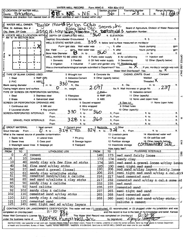
Lithologic Log
(Log data entered by KGS.) |
| |
From: 0 ft. to .6 ft. |
cement |
| |
From: .6 ft. to 10 ft. |
loess |
| |
From: 10 ft. to 40 ft. |
sandy clay with a few fine sand streaks |
| |
From: 40 ft. to 54 ft. |
fine sand with clay streaks |
| |
From: 54 ft. to 57 ft. |
medium sand and gravel (loose) |
| |
From: 57 ft. to 61 ft. |
sandy clay with caliche streaks |
| |
From: 61 ft. to 66 ft. |
cemented sand/with clay and caliche |
| |
From: 66 ft. to 85 ft. |
medium sand with caliche and clay streaks |
| |
From: 85 ft. to 90 ft. |
sandy clay and caliche |
| |
From: 90 ft. to 92 ft. |
hard caliche |
| |
From: 92 ft. to 102 ft. |
sandy clay and caliche |
| |
From: 102 ft. to 110 ft. |
cemented sand with clay streaks |
| |
From: 110 ft. to 121 ft. |
sandy clay and caliche |
| |
From: 121 ft. to 125 ft. |
cemented sand |
| |
From: 125 ft. to 149 ft. |
semi tight medium sand with clay layers |
| |
From: 149 ft. to 173 ft. |
medium sand fairly loose |
| |
From: 173 ft. to 174 ft. |
sandy clay |
| |
From: 174 ft. to 185 ft. |
medium sand and gravel loose with clay lense |
| |
From: 185 ft. to 190 ft. |
semi tight medium sand |
| |
From: 190 ft. to 206 ft. |
medium sand with clay layers fairly loose |
| |
From: 206 ft. to 216 ft. |
semi tight medium sand with clay and caliche streak |
| |
From: 216 ft. to 217 ft. |
hard cemented sand |
| |
From: 217 ft. to 232 ft. |
cemented sand with clay and caliche and some sand |
| |
From: 232 ft. to 235 ft. |
medium sand |
| |
From: 235 ft. to 237 ft. |
cemented sand |
| |
From: 237 ft. to 265 ft. |
semi tight medium sand |
| |
From: 265 ft. to 268 ft. |
hard cemented sand |
| |
From: 268 ft. to 360 ft. |
semi tight medium sand with clay streaks, caliche and cement |