|
|
|
Specific Water Well Detail |
|
|
| Location Info | |||
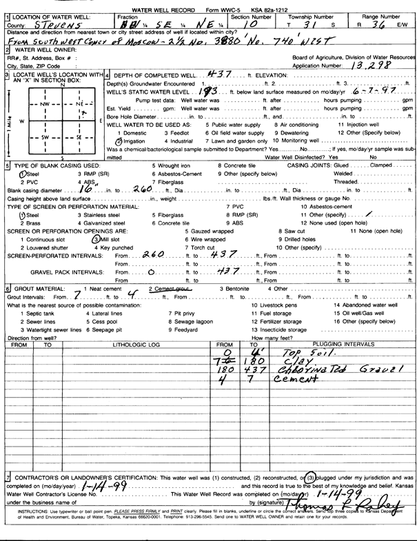
| Owner: Lahey, Tom | Status: Plugged | ||
| Location: T31S, R36W, Sec. 10, NW SE NE | County: Stevens | ||
| Directions: from SW Corner of Moscow, 2.5 mi N, 3880 feet N and 740 feet W | |||
| Latitude: 37.3687081 | Longitude: -101.2158934 | Datum NAD 27 | |
| Latitude: 37.3687319 | Longitude: -101.216334 | Datum NAD 83 | |
| Longitude and latitude calculated by Survey from township-range-section-quarter calls. Only good to within the quarter call accuracy. | |||
| View well on interactive map | |||
| General Info | ||
| Well Depth: 437 ft. | Elevation: ft. | |
| Static Water Level: 193 ft. | Est. Yield: gpm. | |
| Comp. Date: 14-Jan-1999 | Well Use: Irrigation | |
| DWR Applic. #: 13298 | Other ID: | |
| Links | |
| View info from Wizard Water Level Data base... | |
| View info from WIMAS Water Right Data base... | |
| Driller Info | ||
| Driller: well owner | License #: | |
| Scanned Form | View scan |
| Casing Info | ||
|
Casing Type:
Diam: in. Casing height above land surface: in | ||
| Grout Info | ||
| Grout used: | From: to ft | |
| Source of Possible Contamination | ||
| Source: | ||
| Direction from well: | Distance: ft | |