|
|
|
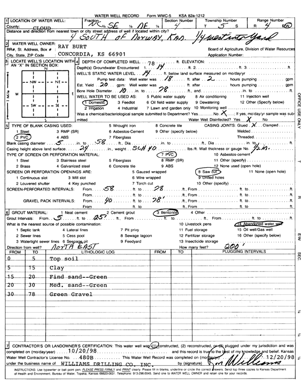
Specific Water Well Detail |
|
|
| Location Info | |||
| Owner: Burt, Ray | Status: Constructed | ||
| Location: T5S, R4W, Sec. 4, SE NE | County: Cloud | ||
| Directions: from Norway: 4 mi S, .25 mi W into yard | |||
| Latitude: 39.6481714 | Longitude: -97.7648608 | Datum NAD 27 | |
| Latitude: 39.6481763 | Longitude: -97.7651809 | Datum NAD 83 | |
| Longitude and latitude calculated by Survey from township-range-section-quarter calls. Only good to within the quarter call accuracy. | |||
| View well on interactive map | |||
| General Info | ||
| Well Depth: 78 ft. | Elevation: ft. | |
| Static Water Level: 14 ft. | Est. Yield: 20 gpm. | |
| Comp. Date: 20-Oct-1998 | Well Use: Domestic | |
| DWR Applic. #: | Other ID: | |
| Driller Info | ||
| Driller: Williams Drilling Co., Inc. | License #: 480 | |
| Scanned Form | View scan |
|
Chemical Sample Submitted?:
Water Well disinfected?: | ||
| Casing Info | ||
| Casing Type:
Casing Joints: |
Diam: in. to ft | |
| Casing height above land surface: in
Casing Weight: lbs/ft Wall thickness or gauge no.: | ||
| Screen and Perforation Info | ||
| Screen Type: | Screen Openings: | |
| Screen-perforated intervals | From: ft to ft | |
| Gravel pack intervals | From: ft to ft | |
| Grout Info | ||
| Grout used: | From: to ft | |
| Source of Possible Contamination | ||
| Source: | ||
| Direction from well: | Distance: ft | |
| Lithologic Log
(Log data entered by KGS.) | ||
| From: 0 ft. to 5 ft. | top soil | |
| From: 5 ft. to 15 ft. | clay | |
| From: 15 ft. to 20 ft. | fine sand, green | |
| From: 20 ft. to 30 ft. | medium sand, green | |
| From: 30 ft. to 78 ft. | green gravel | |