|
|
|
Specific Water Well Detail |
|
|
| Location Info | |||
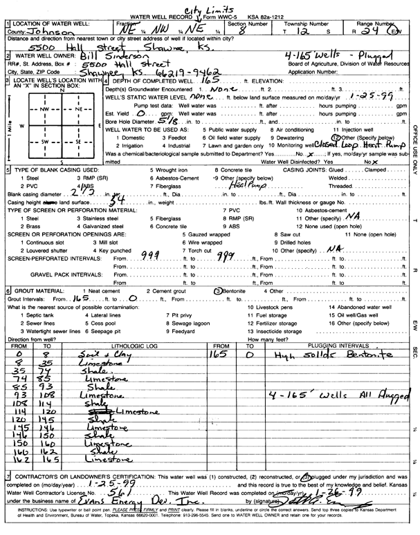
| Owner: Sinderson, Bill | Status: Constructed | ||
| Location: T12S, R24E, Sec. 8, NE NW NE | County: Johnson | ||
| Directions: 5500 Hall Street, Shawnee (four 165-foot bores) | |||
| Latitude: 39.0284224 | Longitude: -94.7668086 | Datum NAD 27 | |
| Latitude: 39.0284276 | Longitude: -94.7670476 | Datum NAD 83 | |
| Longitude and latitude calculated by Survey from township-range-section-quarter calls. Only good to within the quarter call accuracy. | |||
| View well on interactive map | |||
| General Info | ||
| Well Depth: 165 ft. | Elevation: ft. | |
| Static Water Level: ft. | Est. Yield: gpm. | |
| Comp. Date: 25-Jan-1999 | Well Use: Heat Pump (Closed Loop/Disposal), Geothermal | |
| DWR Applic. #: | Other ID: | |
| Driller Info | ||
| Driller: Evans Energy Development, Inc. | License #: 561 | |
| Scanned Form | View scan |
|
Chemical Sample Submitted?:
Water Well disinfected?: | ||
| Casing Info | ||
| Casing Type:
Casing Joints: |
Diam: in. to ft | |
| Casing height above land surface: in
Casing Weight: lbs/ft Wall thickness or gauge no.: | ||
| Screen and Perforation Info | ||
| Screen Type: | Screen Openings: | |
| Screen-perforated intervals | From: ft to ft | |
| Gravel pack intervals | From: ft to ft | |
| Grout Info | ||
| Grout used: | From: to ft | |
| Source of Possible Contamination | ||
| Source: | ||
| Direction from well: | Distance: ft | |
| Lithologic Log
(Log data entered by KGS.) | ||
| From: 0 ft. to 8 ft. | soil and clay | |
| From: 8 ft. to 35 ft. | limestone | |
| From: 35 ft. to 74 ft. | shale | |
| From: 74 ft. to 85 ft. | limestone | |
| From: 85 ft. to 93 ft. | shale | |
| From: 93 ft. to 108 ft. | limestone | |
| From: 108 ft. to 114 ft. | shale | |
| From: 114 ft. to 120 ft. | limestone | |
| From: 120 ft. to 145 ft. | shale | |
| From: 145 ft. to 146 ft. | limestone | |
| From: 146 ft. to 150 ft. | shale | |
| From: 150 ft. to 160 ft. | limestone | |
| From: 160 ft. to 162 ft. | shale | |
| From: 162 ft. to 165 ft. | limestone | |