|
|
|
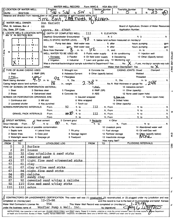
Specific Water Well Detail |
|
|
| Location Info | |||
| Owner: Hazlett, Don | Status: Constructed | ||
| Location: T5S, R23W, Sec. 5, SW SW SW | County: Norton | ||
| Directions: from Lenora, 3 mi E and 2 mi N | |||
| Latitude: 39.6402757 | Longitude: -99.9445389 | Datum NAD 27 | |
| Latitude: 39.6402806 | Longitude: -99.9449414 | Datum NAD 83 | |
| Longitude and latitude calculated by Survey from township-range-section-quarter calls. Only good to within the quarter call accuracy. | |||
| View well on interactive map | |||
| General Info | ||
| Well Depth: 112 ft. | Elevation: ft. | |
| Static Water Level: 93 ft. | Est. Yield: gpm. | |
| Comp. Date: 15-Dec-1998 | Well Use: Domestic | |
| DWR Applic. #: | Other ID: | |
| Driller Info | ||
| Driller: Woofter Pump & Well, Inc. | License #: 554 | |
| Scanned Form | View scan |
|
Chemical Sample Submitted?:
Water Well disinfected?: | ||
| Casing Info | ||
| Casing Type:
Casing Joints: |
Diam: in. to ft | |
| Casing height above land surface: in
Casing Weight: lbs/ft Wall thickness or gauge no.: | ||
| Screen and Perforation Info | ||
| Screen Type: | Screen Openings: | |
| Screen-perforated intervals | From: ft to ft | |
| Gravel pack intervals | From: ft to ft | |
| Grout Info | ||
| Grout used: | From: to ft | |
| Source of Possible Contamination | ||
| Source: | ||
| Direction from well: | Distance: ft | |
| Lithologic Log
(Log data entered by KGS.) | ||
| From: 0 ft. to 2 ft. | surface | |
| From: 2 ft. to 20 ft. | loess | |
| From: 20 ft. to 32 ft. | clay with caliche and sand streaks | |
| From: 32 ft. to 43 ft. | cemented sand | |
| From: 43 ft. to 57 ft. | tight fine sand with cemented streaks | |
| From: 57 ft. to 61 ft. | clay | |
| From: 61 ft. to 67 ft. | clay with fine sand streaks | |
| From: 67 ft. to 84 ft. | tight fine sand streaks | |
| From: 84 ft. to 85 ft. | caliche | |
| From: 85 ft. to 87 ft. | sandy clay | |
| From: 87 ft. to 92 ft. | cemented sand with clay and caliche | |
| From: 92 ft. to 110 ft. | fine medium sand with clay streaks | |
| From: 110 ft. to 112 ft. | ochre | |