|
|
|
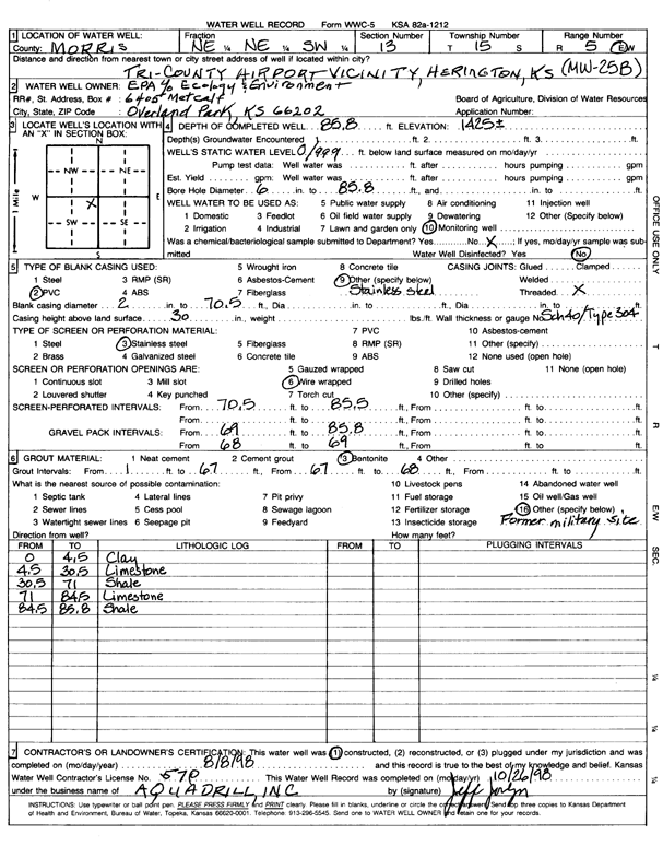
Specific Water Well Detail |
|
|
| Location Info | |||
| Owner: U.S. EPA | Status: Constructed | ||
| Location: T15S, R5E, Sec. 13, NE NE SW | County: Morris | ||
| Directions: Tri- County Airport Vicinity, Herington | |||
| Latitude: 38.745994 | Longitude: -96.8261595 | Datum NAD 27 | |
| Latitude: 38.7459997 | Longitude: -96.8264477 | Datum NAD 83 | |
| Longitude and latitude calculated by Survey from township-range-section-quarter calls. Only good to within the quarter call accuracy. | |||
| View well on interactive map | |||
| General Info | ||
| Well Depth: 85.8 ft. | Elevation: 1425 ft. | |
| Static Water Level: ft. | Est. Yield: gpm. | |
| Comp. Date: 08-Aug-1998 | Well Use: Monitoring well/observation/piezometer | |
| DWR Applic. #: | Other ID: MW 25 B | |
| Driller Info | ||
| Driller: Aquadrill, Inc | License #: 570 | |
| Scanned Form | View scan |
|
Chemical Sample Submitted?:
Water Well disinfected?: | ||
| Casing Info | ||
| Casing Type:
Casing Joints: |
Diam: in. to ft | |
| Casing height above land surface: in
Casing Weight: lbs/ft Wall thickness or gauge no.: | ||
| Screen and Perforation Info | ||
| Screen Type: | Screen Openings: | |
| Screen-perforated intervals | From: ft to ft | |
| Gravel pack intervals | From: ft to ft | |
| Grout Info | ||
| Grout used: | From: to ft | |
| Source of Possible Contamination | ||
| Source: | ||
| Direction from well: | Distance: ft | |
| Lithologic Log
(Log data entered by KGS.) | ||
| From: 0 ft. to 4.5 ft. | clay | |
| From: 4.5 ft. to 30.5 ft. | limestone | |
| From: 30.5 ft. to 71 ft. | shale | |
| From: 71 ft. to 84.5 ft. | limestone | |
| From: 84.5 ft. to 85.8 ft. | shale | |