|
|
|
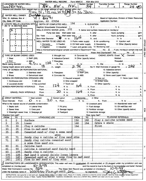
Specific Water Well Detail |
|
|
| Location Info | |||
| Owner: Sprigg, Dwight | Status: Constructed | ||
| Location: T1S, R24W, Sec. 34, NW NW NW | County: Norton | ||
| Directions: from Jct. 36 and 283 in Norton, 7 mi N and 0.5 mi W | |||
| Latitude: 39.9281963 | Longitude: -100.0183554 | Datum NAD 27 | |
| Latitude: 39.9282019 | Longitude: -100.018762 | Datum NAD 83 | |
| Longitude and latitude calculated by Survey from township-range-section-quarter calls. Only good to within the quarter call accuracy. | |||
| View well on interactive map | |||
| General Info | ||
| Well Depth: 164 ft. | Elevation: ft. | |
| Static Water Level: 102 ft. | Est. Yield: gpm. | |
| Comp. Date: 08-Oct-1998 | Well Use: Domestic | |
| DWR Applic. #: | Other ID: | |
| Driller Info | ||
| Driller: Woofter Pump & Well, Inc. | License #: 554 | |
| Scanned Form | View scan |
|
Chemical Sample Submitted?:
Water Well disinfected?: | ||
| Casing Info | ||
| Casing Type:
Casing Joints: |
Diam: in. to ft | |
| Casing height above land surface: in
Casing Weight: lbs/ft Wall thickness or gauge no.: | ||
| Screen and Perforation Info | ||
| Screen Type: | Screen Openings: | |
| Screen-perforated intervals | From: ft to ft | |
| Gravel pack intervals | From: ft to ft | |
| Grout Info | ||
| Grout used: | From: to ft | |
| Source of Possible Contamination | ||
| Source: | ||
| Direction from well: | Distance: ft | |
| Lithologic Log
(Log data entered by KGS.) | ||
| From: 0 ft. to 2 ft. | surface | |
| From: 2 ft. to 15 ft. | loess | |
| From: 15 ft. to 30 ft. | clay and caliche | |
| From: 30 ft. to 35 ft. | fine to medium sand loose | |
| From: 35 ft. to 65 ft. | cemented sand with clay and some sand streaks | |
| From: 65 ft. to 71 ft. | sandy clay and caliche with fine sand streaks | |
| From: 71 ft. to 80 ft. | sandy clay caliche cemented sand and some fine sand mix | |
| From: 80 ft. to 81 ft. | caliche hard | |
| From: 81 ft. to 90 ft. | caliche and cemented sand fairly hard | |
| From: 90 ft. to 105 ft. | sandy clay and caliche | |
| From: 105 ft. to 125 ft. | medium sand and gravel fairly loose layers | |
| From: 125 ft. to 140 ft. | cemented sand with clay and some fine to medium sand | |
| From: 140 ft. to 150 ft. | fine to medium sand with clay streaks | |
| From: 150 ft. to 160 ft. | clay and caliche with some sand | |
| From: 160 ft. to 164 ft. | ochre and shale | |
| From: 164 ft. to ft. | flint | |