|
|
|
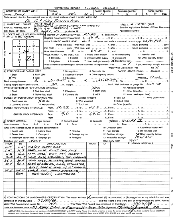
Specific Water Well Detail |
|
|
| Location Info | |||
| Owner: Fort Riley Directorate of Environment and Safety | Status: Constructed | ||
| Location: T11S, R6E, Sec. 14, SW NW SE | County: Riley | ||
| Directions: On Fort Riley Reservation | |||
| Latitude: 39.0920872 | Longitude: -96.7326023 | Datum NAD 27 | |
| Latitude: 39.0920849 | Longitude: -96.7328868 | Datum NAD 83 | |
| Longitude and latitude calculated by Survey from township-range-section-quarter calls. Only good to within the quarter call accuracy. | |||
| View well on interactive map | |||
| General Info | ||
| Well Depth: 27.55 ft. | Elevation: ft. | |
| Static Water Level: 16.4 ft. | Est. Yield: gpm. | |
| Comp. Date: 28-Apr-1998 | Well Use: Monitoring well/observation/piezometer | |
| DWR Applic. #: | Other ID: CF 98-701 | |
| Driller Info | ||
| Driller: USACE | License #: | |
| Scanned Form | View scan |
|
Chemical Sample Submitted?:
Water Well disinfected?: | ||
| Casing Info | ||
| Casing Type:
Casing Joints: |
Diam: in. to ft | |
| Casing height above land surface: in
Casing Weight: lbs/ft Wall thickness or gauge no.: | ||
| Screen and Perforation Info | ||
| Screen Type: | Screen Openings: | |
| Screen-perforated intervals | From: ft to ft | |
| Gravel pack intervals | From: ft to ft | |
| Grout Info | ||
| Grout used: | From: to ft | |
| Source of Possible Contamination | ||
| Source: | ||
| Direction from well: | Distance: ft | |
| Lithologic Log
(Log data entered by KGS.) | ||
| From: 0 ft. to 1.4 ft. | clayey sandy silt | |
| From: 1.4 ft. to 11.5 ft. | fine sand, loose, moist, tan | |
| From: 11.5 ft. to 16.2 ft. | medium sand, loose, wet, tan | |
| From: 16.2 ft. to 24.2 ft. | medium sand, loose, saturated, gray | |
| From: 24.2 ft. to 30 ft. | coarse sand, loose, saturated, gray | |
| From: 30 ft. to 62.6 ft. | sand with gravel, loose, saturated, gray, coarse sand with 2-inch gravel | |
| From: 62.6 ft. to 64 ft. | weathered shale, soft, thinly laminated, olive green | |