|
|
|
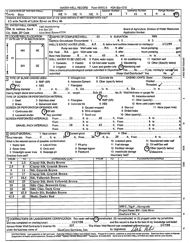
Specific Water Well Detail |
|
|
| Location Info | |||
| Owner: T and E Manufacturing | Status: Constructed | ||
| Location: T19S, R6W, Sec. 18, NE NE NE | County: Rice | ||
| Directions: from Little River: .5 mi N on Hwy 46 | |||
| Latitude: 38.4048075 | Longitude: -98.0176902 | Datum NAD 27 | |
| Latitude: 38.4048172 | Longitude: -98.0180202 | Datum NAD 83 | |
| Longitude and latitude calculated by Survey from township-range-section-quarter calls. Only good to within the quarter call accuracy. | |||
| View well on interactive map | |||
| General Info | ||
| Well Depth: 43 ft. | Elevation: ft. | |
| Static Water Level: 6.5 ft. | Est. Yield: gpm. | |
| Comp. Date: 17-Dec-1998 | Well Use: Monitoring well/observation/piezometer | |
| DWR Applic. #: | Other ID: MW 2 | |
| Driller Info | ||
| Driller: GeoCore Services Inc. | License #: 527 | |
| Scanned Form | View scan |
|
Chemical Sample Submitted?:
Water Well disinfected?: | ||
| Casing Info | ||
| Casing Type:
Casing Joints: |
Diam: in. to ft | |
| Casing height above land surface: in
Casing Weight: lbs/ft Wall thickness or gauge no.: | ||
| Screen and Perforation Info | ||
| Screen Type: | Screen Openings: | |
| Screen-perforated intervals | From: ft to ft | |
| Gravel pack intervals | From: ft to ft | |
| Grout Info | ||
| Grout used: | From: to ft | |
| Source of Possible Contamination | ||
| Source: | ||
| Direction from well: | Distance: ft | |
| Lithologic Log
(Log data entered by KGS.) | ||
| From: 0 ft. to 2.5 ft. | clayey silt, dusky brown | |
| From: 2.5 ft. to 5 ft. | clayey silt, grayish brown | |
| From: 5 ft. to 11 ft. | silt, grayish brown | |
| From: 11 ft. to 17 ft. | clayey silt, grayish brown | |
| From: 17 ft. to 18.5 ft. | silt, yellowish brown | |
| From: 18.5 ft. to 29 ft. | clayey silt, dark yellowish brown | |
| From: 29 ft. to 35 ft. | silty clay, brownish gray | |
| From: 35 ft. to 40 ft. | silty clay, dark gray | |
| From: 40 ft. to 42.5 ft. | sandy silt, reddish brown | |
| From: 42.5 ft. to 43 ft. | shale, dusky red | |