|
|
|
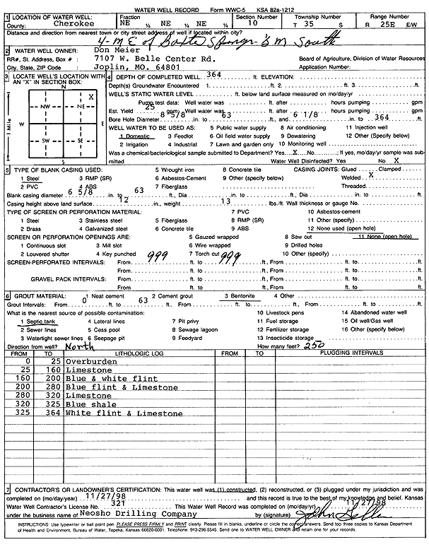
Specific Water Well Detail |
|
|
| Location Info | |||
| Owner: Meier, Don | Status: Constructed | ||
| Location: T35S, R25E, Sec. 10, NE NE NE | County: Cherokee | ||
| Directions: from Baxter Springs: 4 mi E, .5 mi S | |||
| Latitude: 37.0154006 | Longitude: -94.6500836 | Datum NAD 27 | |
| Latitude: 37.0154647 | Longitude: -94.6503087 | Datum NAD 83 | |
| Longitude and latitude calculated by Survey from township-range-section-quarter calls. Only good to within the quarter call accuracy. | |||
| View well on interactive map | |||
| General Info | ||
| Well Depth: 364 ft. | Elevation: ft. | |
| Static Water Level: ft. | Est. Yield: 25 gpm. | |
| Comp. Date: 27-Nov-1998 | Well Use: Domestic | |
| DWR Applic. #: | Other ID: | |
| Driller Info | ||
| Driller: Neosho Drilling Co. | License #: 321 | |
| Scanned Form | View scan |
|
Chemical Sample Submitted?:
Water Well disinfected?: | ||
| Casing Info | ||
| Casing Type:
Casing Joints: |
Diam: in. to ft | |
| Casing height above land surface: in
Casing Weight: lbs/ft Wall thickness or gauge no.: | ||
| Screen and Perforation Info | ||
| Screen Type: | Screen Openings: | |
| Screen-perforated intervals | From: ft to ft | |
| Gravel pack intervals | From: ft to ft | |
| Grout Info | ||
| Grout used: | From: to ft | |
| Source of Possible Contamination | ||
| Source: | ||
| Direction from well: | Distance: ft | |
| Lithologic Log
(Log data entered by KGS.) | ||
| From: 0 ft. to 25 ft. | Overburden | |
| From: 25 ft. to 160 ft. | Limestone | |
| From: 160 ft. to 200 ft. | Blue and white flint | |
| From: 200 ft. to 280 ft. | Blue flint and limestone | |
| From: 280 ft. to 320 ft. | Limestone | |
| From: 320 ft. to 325 ft. | Blue shale | |
| From: 325 ft. to 364 ft. | White flint and limestone | |