|
|
|
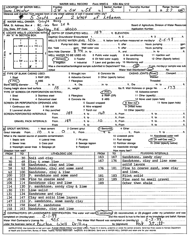
Specific Water Well Detail |
|
|
| Location Info | |||
| Owner: Haag, Gayle | Status: Constructed | ||
| Location: T1S, R27W, Sec. 2, SW SW SE | County: Decatur | ||
| Directions: from Lebanon, 5 mi S, 2 mi W | |||
| Latitude: 39.9884681 | Longitude: -100.316866 | Datum NAD 27 | |
| Latitude: 39.9884738 | Longitude: -100.3172855 | Datum NAD 83 | |
| Longitude and latitude calculated by Survey from township-range-section-quarter calls. Only good to within the quarter call accuracy. | |||
| View well on interactive map | |||
| General Info | ||
| Well Depth: 189 ft. | Elevation: ft. | |
| Static Water Level: 126 ft. | Est. Yield: gpm. | |
| Comp. Date: 01-Feb-1999 | Well Use: Domestic | |
| DWR Applic. #: | Other ID: | |
| Driller Info | ||
| Driller: Burton Well Drilling, Inc. | License #: 425 | |
| Scanned Form | View scan |
|
Chemical Sample Submitted?:
Water Well disinfected?: | ||
| Casing Info | ||
| Casing Type:
Casing Joints: |
Diam: in. to ft | |
| Casing height above land surface: in
Casing Weight: lbs/ft Wall thickness or gauge no.: | ||
| Screen and Perforation Info | ||
| Screen Type: | Screen Openings: | |
| Screen-perforated intervals | From: ft to ft | |
| Gravel pack intervals | From: ft to ft | |
| Grout Info | ||
| Grout used: | From: to ft | |
| Source of Possible Contamination | ||
| Source: | ||
| Direction from well: | Distance: ft | |
| Lithologic Log
(Log data entered by KGS.) | ||
| From: 0 ft. to 30 ft. | soil and clay | |
| From: 30 ft. to 48 ft. | clay and some lime | |
| From: 48 ft. to 58 ft. | sandstone, clay and lime | |
| From: 58 ft. to 62 ft. | sandstone, clay and some sand | |
| From: 62 ft. to 100 ft. | sandstone, clay and lime | |
| From: 100 ft. to 103 ft. | porous sandstone and some sand | |
| From: 103 ft. to 106 ft. | fine to coarse sand | |
| From: 106 ft. to 114 ft. | sandstone clay and lime | |
| From: 114 ft. to 130 ft. | porous sandstone, sandy clay and lime | |
| From: 130 ft. to 131 ft. | lime solid | |
| From: 131 ft. to 134 ft. | sandstone and clay | |
| From: 134 ft. to 147 ft. | clay and solid lime layers | |
| From: 147 ft. to 153 ft. | porous sandstone, some sandy clay | |
| From: 153 ft. to 158 ft. | good porous sandstone | |
| From: 158 ft. to 163 ft. | sandstone, clay and lime | |
| From: 163 ft. to 167 ft. | sandstone, sandy clay | |
| From: 167 ft. to 176 ft. | sandstone, clay and lime some solid layers | |
| From: 176 ft. to 181 ft. | fine to coarse sand, some clay and lime | |
| From: 181 ft. to 183 ft. | flint solid | |
| From: 183 ft. to 189 ft. | fine sand to small gravel | |
| From: 189 ft. to ft. | ochre then shale | |