|
|
|
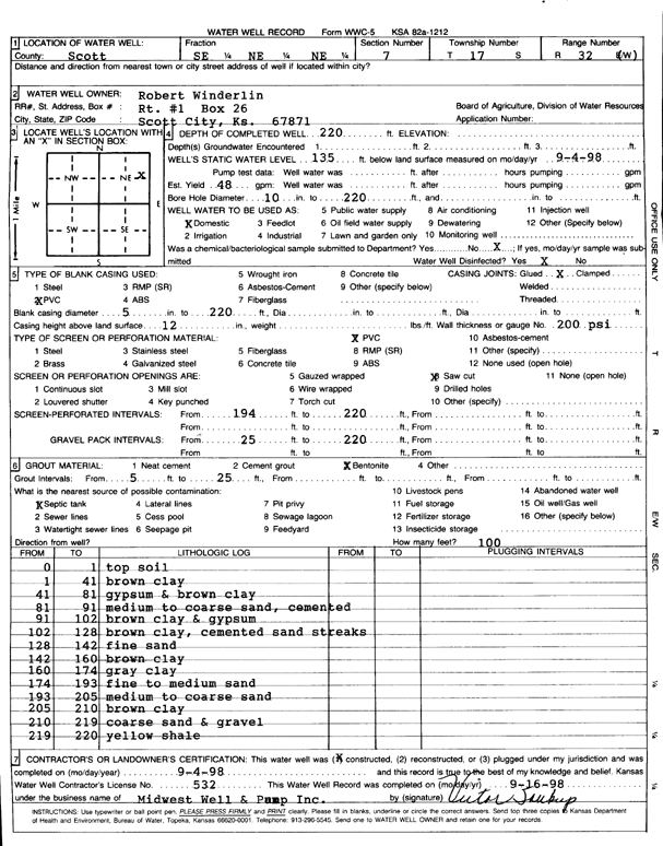
Specific Water Well Detail |
|
|
| Location Info | |||
| Owner: Winderlin, Robert | Status: Constructed | ||
| Location: T17S, R32W, Sec. 7, SE NE NE | County: Scott | ||
| Directions: | |||
| Latitude: 38.5958483 | Longitude: -100.8900634 | Datum NAD 27 | |
| Latitude: 38.5958654 | Longitude: -100.89049 | Datum NAD 83 | |
| Longitude and latitude calculated by Survey from township-range-section-quarter calls. Only good to within the quarter call accuracy. | |||
| View well on interactive map | |||
| General Info | ||
| Well Depth: 220 ft. | Elevation: ft. | |
| Static Water Level: 135 ft. | Est. Yield: 48 gpm. | |
| Comp. Date: 04-Sep-1998 | Well Use: Domestic | |
| DWR Applic. #: | Other ID: | |
| Driller Info | ||
| Driller: Midwest Well & Pump, Inc. | License #: 532 | |
| Scanned Form | View scan |
|
Chemical Sample Submitted?:
Water Well disinfected?: | ||
| Casing Info | ||
| Casing Type:
Casing Joints: |
Diam: in. to ft | |
| Casing height above land surface: in
Casing Weight: lbs/ft Wall thickness or gauge no.: | ||
| Screen and Perforation Info | ||
| Screen Type: | Screen Openings: | |
| Screen-perforated intervals | From: ft to ft | |
| Gravel pack intervals | From: ft to ft | |
| Grout Info | ||
| Grout used: | From: to ft | |
| Source of Possible Contamination | ||
| Source: | ||
| Direction from well: | Distance: ft | |
| Lithologic Log
(Log data entered by KGS.) | ||
| From: 0 ft. to 1 ft. | top soil | |
| From: 1 ft. to 41 ft. | brown clay | |
| From: 41 ft. to 81 ft. | gypsum and brown clay | |
| From: 81 ft. to 91 ft. | medium to coarse sand, cemented | |
| From: 91 ft. to 102 ft. | brown clay and gypsum | |
| From: 102 ft. to 128 ft. | brown clay, cemented sand streaks | |
| From: 128 ft. to 142 ft. | fine sand | |
| From: 142 ft. to 160 ft. | brown clay | |
| From: 160 ft. to 174 ft. | gray clay | |
| From: 174 ft. to 193 ft. | fine to medium sand | |
| From: 193 ft. to 205 ft. | medium to coarse sand | |
| From: 205 ft. to 210 ft. | brown clay | |
| From: 210 ft. to 219 ft. | coarse sand and gravel | |
| From: 219 ft. to 220 ft. | yellow shale | |