|
|
|
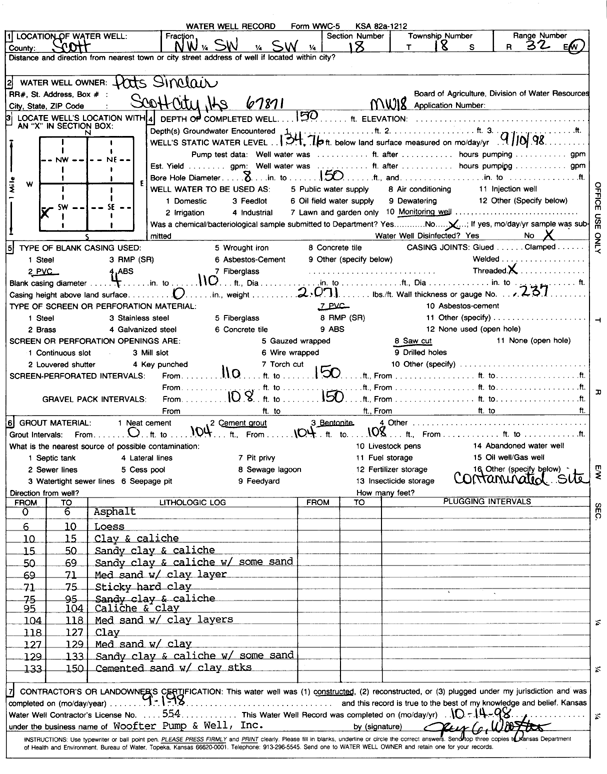
Specific Water Well Detail |
|
|
| Location Info | |||
| Owner: Pat's Sinclair | Status: Constructed | ||
| Location: T18S, R32W, Sec. 18, NW SW SW | County: Scott | ||
| Directions: | |||
| Latitude: 38.4851903 | Longitude: -100.9054209 | Datum NAD 27 | |
| Latitude: 38.4852095 | Longitude: -100.905849 | Datum NAD 83 | |
| Longitude and latitude calculated by Survey from township-range-section-quarter calls. Only good to within the quarter call accuracy. | |||
| View well on interactive map | |||
| General Info | ||
| Well Depth: 150 ft. | Elevation: ft. | |
| Static Water Level: 134.76 ft. | Est. Yield: gpm. | |
| Comp. Date: 01-Sep-1998 | Well Use: Monitoring well/observation/piezometer | |
| DWR Applic. #: | Other ID: MW 18 | |
| Driller Info | ||
| Driller: Woofter Pump & Well, Inc | License #: 554 | |
| Scanned Form | View scan |
|
Chemical Sample Submitted?:
Water Well disinfected?: | ||
| Casing Info | ||
| Casing Type:
Casing Joints: |
Diam: in. to ft | |
| Casing height above land surface: in
Casing Weight: lbs/ft Wall thickness or gauge no.: | ||
| Screen and Perforation Info | ||
| Screen Type: | Screen Openings: | |
| Screen-perforated intervals | From: ft to ft | |
| Gravel pack intervals | From: ft to ft | |
| Grout Info | ||
| Grout used: | From: to ft | |
| Source of Possible Contamination | ||
| Source: | ||
| Direction from well: | Distance: ft | |
| Lithologic Log
(Log data entered by KGS.) | ||
| From: 0 ft. to 6 ft. | asphalt | |
| From: 6 ft. to 10 ft. | loess | |
| From: 10 ft. to 15 ft. | clay and caliche | |
| From: 15 ft. to 50 ft. | sandy clay and caliche | |
| From: 50 ft. to 69 ft. | sandy clay and caliche with some sand | |
| From: 69 ft. to 71 ft. | med sand with clay layer | |
| From: 71 ft. to 75 ft. | sticky hard clay | |
| From: 75 ft. to 95 ft. | sandy clay and caliche | |
| From: 95 ft. to 104 ft. | caliche and clay | |
| From: 104 ft. to 118 ft. | med sand with clay layers | |
| From: 118 ft. to 127 ft. | clay | |
| From: 127 ft. to 129 ft. | med sand with clay | |
| From: 129 ft. to 133 ft. | sandy clay and caliche with some sand | |
| From: 133 ft. to 150 ft. | cemented sand with clay streaks | |