|
|
|
Specific Water Well Detail |
|
|
| Location Info | |||
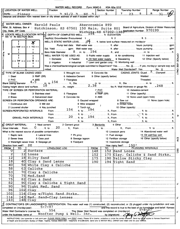
| Owner: Pauls, Harold/Abercrombie Drilling | Status: Constructed | ||
| Location: T23S, R31W, Sec. 9, N2 NE | County: Finney | ||
| Directions: | |||
| Latitude: 38.0737222 | Longitude: -100.7233033 | Datum NAD 27 | |
| Latitude: 38.0737434 | Longitude: -100.7237355 | Datum NAD 83 | |
| Longitude and latitude calculated by Survey from township-range-section-quarter calls. Only good to within the quarter call accuracy. | |||
| View well on interactive map | |||
| General Info | ||
| Well Depth: 194 ft. | Elevation: ft. | |
| Static Water Level: 114 ft. | Est. Yield: gpm. | |
| Comp. Date: 07-May-1997 | Well Use: Oil Field Water Supply | |
| DWR Applic. #: 970199 | Other ID: | |
| Links | |
| No Wizard information available. | |
| View info from WIMAS Water Right Data base... | |
| Driller Info | ||
| Driller: Woofter Pump & Well, Inc. | License #: 554 | |
| Scanned Form | View scan |
|
Chemical Sample Submitted?:
Water Well disinfected?: | ||
| Casing Info | ||
| Casing Type:
Casing Joints: |
Diam: in. to ft | |
| Casing height above land surface: in
Casing Weight: lbs/ft Wall thickness or gauge no.: | ||
| Screen and Perforation Info | ||
| Screen Type: | Screen Openings: | |
| Screen-perforated intervals | From: ft to ft | |
| Gravel pack intervals | From: ft to ft | |
| Grout Info | ||
| Grout used: | From: to ft | |
| Source of Possible Contamination | ||
| Source: | ||
| Direction from well: | Distance: ft | |
| Lithologic Log
(Log data entered by KGS.) | ||
| From: 0 ft. to 2 ft. | surface | |
| From: 2 ft. to 12 ft. | loess | |
| From: 12 ft. to 18 ft. | silty sand | |
| From: 18 ft. to 40 ft. | clay and sand lenses | |
| From: 40 ft. to 58 ft. | white clay and caliche | |
| From: 58 ft. to 63 ft. | caliche | |
| From: 63 ft. to 70 ft. | clay and caliche | |
| From: 70 ft. to 75 ft. | medium sand | |
| From: 75 ft. to 82 ft. | clay and sand | |
| From: 82 ft. to 90 ft. | clay and caliche and tight sand | |
| From: 90 ft. to 96 ft. | tight medium sand | |
| From: 96 ft. to 102 ft. | clay | |
| From: 102 ft. to 114 ft. | clay with tight sand streaks | |
| From: 114 ft. to 143 ft. | medium sand - clay lenses | |
| From: 143 ft. to 148 ft. | clay | |
| From: 148 ft. to 152 ft. | sand loose | |
| From: 152 ft. to 175 ft. | clay, caliche and sand streaks | |
| From: 175 ft. to 190 ft. | yellow sticky clay | |
| From: 190 ft. to 194 ft. | tight sand | |