|
|
|
Specific Water Well Detail |
|
|
| Location Info | |||
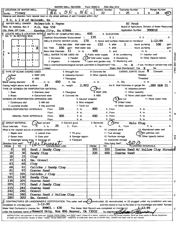
| Owner: Helmerich and Payne Inc. | Status: Constructed | ||
| Location: T25S, R34W, Sec. 22, NE SE NE | County: Finney | ||
| Directions: from Holcomb, 8 mi S and 2 mi W | |||
| Latitude: 37.8683833 | Longitude: -101.0304796 | Datum NAD 27 | |
| Latitude: 37.8684067 | Longitude: -101.0309257 | Datum NAD 83 | |
| Longitude and latitude calculated by Survey from township-range-section-quarter calls. Only good to within the quarter call accuracy. | |||
| View well on interactive map | |||
| General Info | ||
| Well Depth: 400 ft. | Elevation: ft. | |
| Static Water Level: 170 ft. | Est. Yield: 100 gpm. | |
| Comp. Date: 12-Jan-1999 | Well Use: Oil Field Water Supply | |
| DWR Applic. #: 990018 | Other ID: Fred 2 | |
| Links | |
| No Wizard information available. | |
| View info from WIMAS Water Right Data base... | |
| Driller Info | ||
| Driller: Howard Drilling Company AG, LLC | License #: 430 | |
| Scanned Form | View scan |
|
Chemical Sample Submitted?:
Water Well disinfected?: | ||
| Casing Info | ||
| Casing Type:
Casing Joints: |
Diam: in. to ft | |
| Casing height above land surface: in
Casing Weight: lbs/ft Wall thickness or gauge no.: | ||
| Screen and Perforation Info | ||
| Screen Type: | Screen Openings: | |
| Screen-perforated intervals | From: ft to ft | |
| Gravel pack intervals | From: ft to ft | |
| Grout Info | ||
| Grout used: | From: to ft | |
| Source of Possible Contamination | ||
| Source: | ||
| Direction from well: | Distance: ft | |
| Lithologic Log
(Log data entered by KGS.) | ||
| From: 0 ft. to 10 ft. | sand / sandy clay | |
| From: 10 ft. to 30 ft. | sandy clay | |
| From: 30 ft. to 37 ft. | clay | |
| From: 37 ft. to 63 ft. | small gravel | |
| From: 63 ft. to 68 ft. | clay | |
| From: 68 ft. to 81 ft. | caliche / sandy clay | |
| From: 81 ft. to 97 ft. | coarse sand | |
| From: 97 ft. to 105 ft. | caliche / clay | |
| From: 105 ft. to 130 ft. | sandy clay | |
| From: 130 ft. to 205 ft. | coarse sand | |
| From: 205 ft. to 215 ft. | sand / sandy clay | |
| From: 215 ft. to 242 ft. | coarse sand | |
| From: 242 ft. to 246 ft. | gravel | |
| From: 246 ft. to 280 ft. | coarse sand / yellow clay | |
| From: 280 ft. to 305 ft. | small gravel | |
| From: 305 ft. to 320 ft. | coarse sand with yellow clay streaks | |
| From: 320 ft. to 400 ft. | coarse sand | |