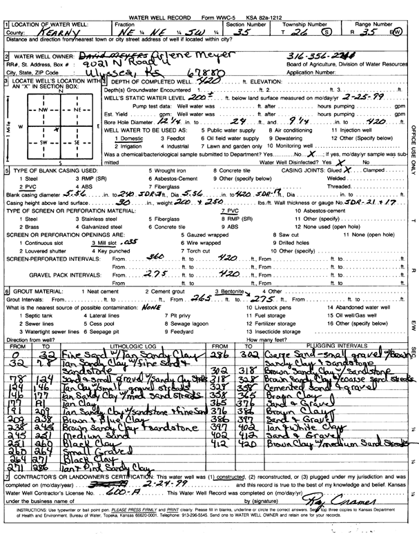
![]() |
![]() |
Specific Water Well Detail |
![]() |
Location Info | |||
Owner: Meyer, Arlene | Status: Constructed | ||
Location: T26S, R35W, Sec. 35, NE NE SW | County: Kearny | ||
Directions: | |||
Latitude: 37.7428011 | Longitude: -101.1178358 | Datum NAD 27 | |
Latitude: 37.7428223 | Longitude: -101.1182841 | Datum NAD 83 | |
Longitude and latitude calculated by Survey from township-range-section-quarter calls. Only good to within the quarter call accuracy. | |||
View well on interactive map |
General Info | ||
Well Depth: 420 ft. | Elevation: ft. | |
Static Water Level: 200 ft. | Est. Yield: gpm. | |
Comp. Date: 24-Feb-1999 | Well Use: Domestic | |
DWR Applic. #: | Other ID: |
Driller Info | ||
Driller: Ray Cramer Drilling Co. | License #: 600 |
Scanned Form | ||
View form(s) on screen | Download scan(s) | |
The download files contain one or more TIFF images compressed into a ZIP archive. Your browser may be already set up to decompress these files. The TIFFs are 300 dpi archival-quality scans of the WWC5 forms and can be viewed by software like Adobe PhotoShop. |
Chemical Sample Submitted?:
Water Well disinfected?: | ||
Casing Info | ||
Casing Type:
Casing Joints: |
Diam: in. to ft | |
Casing height above land surface: in
Casing Weight: lbs/ft Wall thickness or gauge no.: |
Screen and Perforation Info | ||
Screen Type: | Screen Openings: | |
Screen-perforated intervals | From: ft to ft | |
Gravel pack intervals | From: ft to ft |
Grout Info | ||
Grout used: | From: to ft |
Source of Possible Contamination | ||
Source: | ||
Direction from well: | Distance: ft |
Lithologic Log
(Log data entered by KGS.) | ||
From: 0 ft. to 32 ft. | fine sand with tan sandy clay | |
From: 32 ft. to 78 ft. | tan sandy clay with fine sand and sandstone | |
From: 78 ft. to 124 ft. | sand and small gravel with sandy clay streaks | |
From: 124 ft. to 146 ft. | tan clay with small gravel streaks | |
From: 146 ft. to 177 ft. | tan sandy clay with medium sand streaks | |
From: 177 ft. to 191 ft. | tan clay | |
From: 191 ft. to 209 ft. | tan sandy clay with sandstone and fine sand | |
From: 209 ft. to 238 ft. | brown and blue clay | |
From: 238 ft. to 245 ft. | brown sandy clay and sandstone | |
From: 245 ft. to 251 ft. | medium sand | |
From: 251 ft. to 260 ft. | black clay | |
From: 260 ft. to 264 ft. | small gravel | |
From: 264 ft. to 271 ft. | black clay | |
From: 271 ft. to 286 ft. | tan and pink sandy clay | |
From: 286 ft. to 302 ft. | coarse sand, small gravel, with brown sandy clay and sandstone | |
From: 302 ft. to 318 ft. | brown sandy clay with sandstone | |
From: 318 ft. to 328 ft. | brown sandy clay with coarse sand streaks | |
From: 328 ft. to 358 ft. | cemented sand and gravel | |
From: 358 ft. to 365 ft. | brown clay | |
From: 365 ft. to 376 ft. | sand and gravel | |
From: 376 ft. to 386 ft. | brown clay | |
From: 386 ft. to 397 ft. | sand and gravel | |
From: 397 ft. to 402 ft. | tan and white clay | |
From: 402 ft. to 412 ft. | sand and gravel | |
From: 412 ft. to 420 ft. | brown clay with medium sand streaks |