|
|
|
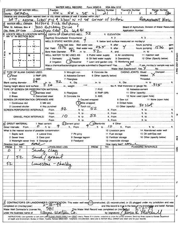
Specific Water Well Detail |
|
|
| Location Info | |||
| Owner: Milford Fish Hatchery | Status: Constructed | ||
| Location: T11S, R5E, Sec. 21, NW NW SE | County: Geary | ||
| Directions: lot 7, 2180 feet E and 2300 feet N of SE corner of section | |||
| Latitude: 39.0801163 | Longitude: -96.8776071 | Datum NAD 27 | |
| Latitude: 39.0801139 | Longitude: -96.8778951 | Datum NAD 83 | |
| Longitude and latitude calculated by Survey from township-range-section-quarter calls. Only good to within the quarter call accuracy. | |||
| View well on interactive map | |||
| General Info | ||
| Well Depth: 52 ft. | Elevation: ft. | |
| Static Water Level: 9 ft. | Est. Yield: 1536 gpm. | |
| Comp. Date: 18-Feb-1999 | Well Use: Industrial | |
| DWR Applic. #: | Other ID: | |
| Driller Info | ||
| Driller: Layne-Western Co. | License #: 581 | |
| Scanned Form | View scan |
|
Chemical Sample Submitted?:
Water Well disinfected?: | ||
| Casing Info | ||
| Casing Type:
Casing Joints: |
Diam: in. to ft | |
| Casing height above land surface: in
Casing Weight: lbs/ft Wall thickness or gauge no.: | ||
| Screen and Perforation Info | ||
| Screen Type: | Screen Openings: | |
| Screen-perforated intervals | From: ft to ft | |
| Gravel pack intervals | From: ft to ft | |
| Grout Info | ||
| Grout used: | From: to ft | |
| Source of Possible Contamination | ||
| Source: | ||
| Direction from well: | Distance: ft | |
| Lithologic Log
(Log data entered by KGS.) | ||
| From: 0 ft. to 1 ft. | sandy clay | |
| From: 1 ft. to 52 ft. | sand and gravel | |
| From: 52 ft. to ft. | limestone, chalky | |