|
|
|
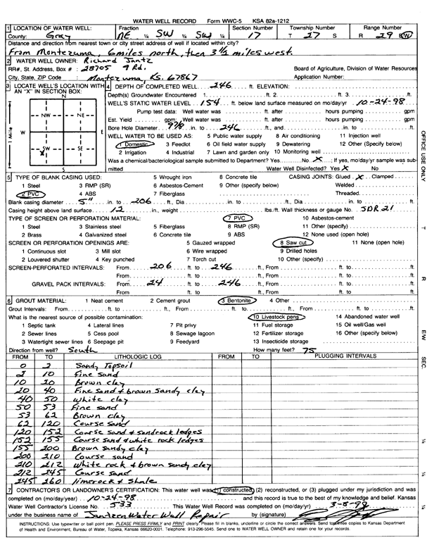
Specific Water Well Detail |
|
|
| Location Info | |||
| Owner: Jantz, Richard | Status: Constructed | ||
| Location: T27S, R29W, Sec. 17, NE SW SW | County: Gray | ||
| Directions: from Montezuma: 6 mi N, 3.5 mi W | |||
| Latitude: 37.6958888 | Longitude: -100.521026 | Datum NAD 27 | |
| Latitude: 37.6959118 | Longitude: -100.5214554 | Datum NAD 83 | |
| Longitude and latitude calculated by Survey from township-range-section-quarter calls. Only good to within the quarter call accuracy. | |||
| View well on interactive map | |||
| General Info | ||
| Well Depth: 246 ft. | Elevation: ft. | |
| Static Water Level: 154 ft. | Est. Yield: gpm. | |
| Comp. Date: 24-Oct-1998 | Well Use: Domestic | |
| DWR Applic. #: | Other ID: | |
| Driller Info | ||
| Driller: Jantzen Water Well Repair | License #: 533 | |
| Scanned Form | View scan |
|
Chemical Sample Submitted?:
Water Well disinfected?: | ||
| Casing Info | ||
| Casing Type:
Casing Joints: |
Diam: in. to ft | |
| Casing height above land surface: in
Casing Weight: lbs/ft Wall thickness or gauge no.: | ||
| Screen and Perforation Info | ||
| Screen Type: | Screen Openings: | |
| Screen-perforated intervals | From: ft to ft | |
| Gravel pack intervals | From: ft to ft | |
| Grout Info | ||
| Grout used: | From: to ft | |
| Source of Possible Contamination | ||
| Source: | ||
| Direction from well: | Distance: ft | |
| Lithologic Log
(Log data entered by KGS.) | ||
| From: 0 ft. to 2 ft. | Sandy Topsoil | |
| From: 2 ft. to 10 ft. | fine sand | |
| From: 10 ft. to 20 ft. | Brown clay | |
| From: 20 ft. to 40 ft. | Fine sand and brown sandy clay | |
| From: 40 ft. to 50 ft. | white clay | |
| From: 50 ft. to 53 ft. | Fine sand | |
| From: 53 ft. to 62 ft. | Brown clay | |
| From: 62 ft. to 120 ft. | Coarse sand | |
| From: 120 ft. to 152 ft. | Coarse sand and sandrock ledges | |
| From: 152 ft. to 155 ft. | Coarse sand and white rock ledges | |
| From: 155 ft. to 200 ft. | Brown sandy clay | |
| From: 200 ft. to 210 ft. | Coarse sand | |
| From: 210 ft. to 212 ft. | White rock and brown sandy clay | |
| From: 212 ft. to 245 ft. | Coarse sand | |
| From: 245 ft. to 260 ft. | limerock and shale | |