|
|
|
Specific Water Well Detail |
|
|
| Location Info | |||
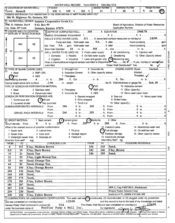
| Owner: Satanta Cooperative Grain Co. | Status: Constructed | ||
| Location: T30S, R34W, Sec. 13, SW SW NE | County: Haskell | ||
| Directions: 506 W Hwy 56, Satanta | |||
| Latitude: 37.4395395 | Longitude: -100.9877346 | Datum NAD 27 | |
| Latitude: 37.4395641 | Longitude: -100.9881794 | Datum NAD 83 | |
| Longitude and latitude calculated by Survey from township-range-section-quarter calls. Only good to within the quarter call accuracy. | |||
| View well on interactive map | |||
| General Info | ||
| Well Depth: 345 ft. | Elevation: 2968.78 ft. | |
| Static Water Level: 311 ft. | Est. Yield: gpm. | |
| Comp. Date: 25-Jan-1999 | Well Use: Monitoring well/observation/piezometer | |
| DWR Applic. #: | Other ID: MW 2 | |
| Driller Info | ||
| Driller: Woofter Pump & Well Inc. | License #: 554 | |
| Scanned Form | View scan |
|
Chemical Sample Submitted?:
Water Well disinfected?: | ||
| Casing Info | ||
| Casing Type:
Casing Joints: |
Diam: in. to ft | |
| Casing height above land surface: in
Casing Weight: lbs/ft Wall thickness or gauge no.: | ||
| Screen and Perforation Info | ||
| Screen Type: | Screen Openings: | |
| Screen-perforated intervals | From: ft to ft | |
| Gravel pack intervals | From: ft to ft | |
| Grout Info | ||
| Grout used: | From: to ft | |
| Source of Possible Contamination | ||
| Source: | ||
| Direction from well: | Distance: ft | |
| Lithologic Log
(Log data entered by KGS.) | ||
| From: 0 ft. to .5 ft. | clay, medium brown | |
| From: .5 ft. to 15 ft. | clay, dark brown | |
| From: 15 ft. to 21 ft. | sand, tan | |
| From: 21 ft. to 53 ft. | clay, light brown/tan | |
| From: 53 ft. to 64 ft. | sand, orange tan | |
| From: 64 ft. to 81 ft. | sand, orange tan | |
| From: 81 ft. to 104 ft. | clay, orange brown | |
| From: 104 ft. to 144 ft. | sand, tan | |
| From: 144 ft. to 155 ft. | sand | |
| From: 155 ft. to 170 ft. | sand | |
| From: 170 ft. to 181 ft. | clay, yellow brown | |
| From: 181 ft. to 207 ft. | sand | |
| From: 207 ft. to 210 ft. | sand | |
| From: 210 ft. to 230 ft. | sand | |
| From: 230 ft. to 236 ft. | clay, yellow brown | |
| From: 236 ft. to 243 ft. | sand | |
| From: 243 ft. to 246 ft. | clay, brown | |
| From: 246 ft. to 355 ft. | sand | |