|
|
|
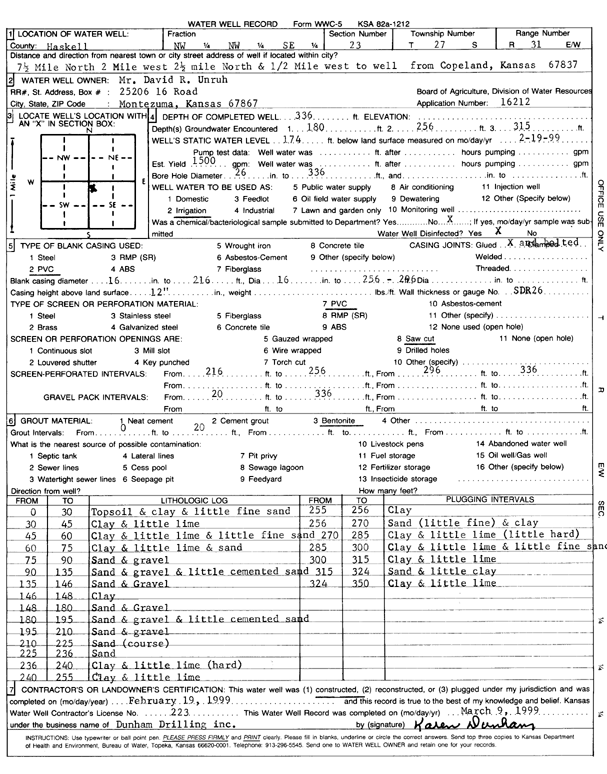
Specific Water Well Detail |
|
|
| Location Info | |||
| Owner: Unruh, David R. | Status: Constructed | ||
| Location: T27S, R31W, Sec. 23, NW NW SE | County: Haskell | ||
| Directions: from Copeland: 7.5 mi N, 2 mi W, 2.5 mi N, .5 mi W to site | |||
| Latitude: 37.6845927 | Longitude: -100.6780754 | Datum NAD 27 | |
| Latitude: 37.6846166 | Longitude: -100.6785101 | Datum NAD 83 | |
| Longitude and latitude calculated by Survey from township-range-section-quarter calls. Only good to within the quarter call accuracy. | |||
| View well on interactive map | |||
| General Info | ||
| Well Depth: 336 ft. | Elevation: ft. | |
| Static Water Level: 174 ft. | Est. Yield: 1500 gpm. | |
| Comp. Date: 19-Feb-1999 | Well Use: Irrigation | |
| DWR Applic. #: 16212 | Other ID: | |
| Links | |
| No Wizard information available. | |
| View info from WIMAS Water Right Data base... | |
| Driller Info | ||
| Driller: Dunham Drilling, Inc. | License #: 223 | |
| Scanned Form | View scan |
|
Chemical Sample Submitted?:
Water Well disinfected?: | ||
| Casing Info | ||
| Casing Type:
Casing Joints: |
Diam: in. to ft | |
| Casing height above land surface: in
Casing Weight: lbs/ft Wall thickness or gauge no.: | ||
| Screen and Perforation Info | ||
| Screen Type: | Screen Openings: | |
| Screen-perforated intervals | From: ft to ft | |
| Gravel pack intervals | From: ft to ft | |
| Grout Info | ||
| Grout used: | From: to ft | |
| Source of Possible Contamination | ||
| Source: | ||
| Direction from well: | Distance: ft | |
| Lithologic Log
(Log data entered by KGS.) | ||
| From: 0 ft. to 30 ft. | topsoil and clay and little fine sand | |
| From: 30 ft. to 45 ft. | clay and little lime | |
| From: 45 ft. to 60 ft. | clay and little lime and little fine sand | |
| From: 60 ft. to 75 ft. | clay and little lime and sand | |
| From: 75 ft. to 90 ft. | sand and gravel | |
| From: 90 ft. to 135 ft. | sand and gravel and little cemented sand | |
| From: 135 ft. to 146 ft. | sand and gravel | |
| From: 146 ft. to 148 ft. | clay | |
| From: 148 ft. to 180 ft. | sand and gravel | |
| From: 180 ft. to 195 ft. | sand and gravel and little cemented sand | |
| From: 195 ft. to 210 ft. | sand and gravel | |
| From: 210 ft. to 225 ft. | coarse sand | |
| From: 225 ft. to 236 ft. | sand | |
| From: 236 ft. to 240 ft. | clay and little lime (hard) | |
| From: 240 ft. to 255 ft. | clay and little lime | |
| From: 255 ft. to 256 ft. | clay | |
| From: 256 ft. to 270 ft. | sand (little fine) and clay | |
| From: 270 ft. to 285 ft. | clay and little lime (little hard) | |
| From: 285 ft. to 300 ft. | clay and little lime and little fine sand | |
| From: 300 ft. to 315 ft. | clay and little lime | |
| From: 315 ft. to 324 ft. | sand and little clay | |
| From: 324 ft. to 350 ft. | clay and little lime | |