|
|
|
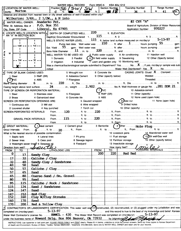
Specific Water Well Detail |
|
|
| Location Info | |||
| Owner: Anadarko Petroleum Corp. | Status: Constructed | ||
| Location: T34S, R41W, Sec. 18, SE SW SW | County: Morton | ||
| Directions: from Wilburton, 0.75 mi N, 2.5 mi W, and N into site | |||
| Latitude: 37.0841858 | Longitude: -101.8235765 | Datum NAD 27 | |
| Latitude: 37.0842097 | Longitude: -101.8240194 | Datum NAD 83 | |
| Longitude and latitude calculated by Survey from township-range-section-quarter calls. Only good to within the quarter call accuracy. | |||
| View well on interactive map | |||
| General Info | ||
| Well Depth: 220 ft. | Elevation: ft. | |
| Static Water Level: 115 ft. | Est. Yield: 55 gpm. | |
| Comp. Date: 13-May-1997 | Well Use: Oil Field Water Supply | |
| DWR Applic. #: 970227 | Other ID: Cyr A 2 | |
| Links | |
| No Wizard information available. | |
| View info from WIMAS Water Right Data base... | |
| Driller Info | ||
| Driller: Howard Drilling Company AG, LLC | License #: 430 | |
| Scanned Form | View scan |
|
Chemical Sample Submitted?:
Water Well disinfected?: | ||
| Casing Info | ||
| Casing Type:
Casing Joints: |
Diam: in. to ft | |
| Casing height above land surface: in
Casing Weight: lbs/ft Wall thickness or gauge no.: | ||
| Screen and Perforation Info | ||
| Screen Type: | Screen Openings: | |
| Screen-perforated intervals | From: ft to ft | |
| Gravel pack intervals | From: ft to ft | |
| Grout Info | ||
| Grout used: | From: to ft | |
| Source of Possible Contamination | ||
| Source: | ||
| Direction from well: | Distance: ft | |
| Lithologic Log
(Log data entered by KGS.) | ||
| From: 0 ft. to 17 ft. | sandy clay | |
| From: 17 ft. to 32 ft. | caliche / clay | |
| From: 32 ft. to 40 ft. | sandy clay / sandstone | |
| From: 40 ft. to 50 ft. | sand | |
| From: 50 ft. to 57 ft. | caliche / clay | |
| From: 57 ft. to 65 ft. | sand | |
| From: 65 ft. to 80 ft. | coarse sand / small gravel | |
| From: 80 ft. to 95 ft. | sand | |
| From: 95 ft. to 115 ft. | caliche / rock / sandstone | |
| From: 115 ft. to 124 ft. | sand / sandstone | |
| From: 124 ft. to 147 ft. | sand | |
| From: 147 ft. to 152 ft. | red clay | |
| From: 152 ft. to 160 ft. | clay with clay streaks | |
| From: 160 ft. to 170 ft. | sand | |
| From: 170 ft. to 200 ft. | red and yellow clay | |
| From: 200 ft. to 220 ft. | red bed | |