|
|
|
Specific Water Well Detail |
|
|
| Location Info | |||
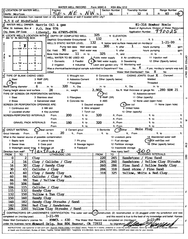
| Owner: Harris Oil and Gas | Status: Constructed | ||
| Location: T32S, R40W, Sec. 16, SE NE NW | County: Morton | ||
| Directions: From Richfield, 5.5 miles East | |||
| Latitude: 37.269733 | Longitude: -101.6743266 | Datum NAD 27 | |
| Latitude: 37.2697565 | Longitude: -101.6747679 | Datum NAD 83 | |
| Longitude and latitude calculated by Survey from township-range-section-quarter calls. Only good to within the quarter call accuracy. | |||
| View well on interactive map | |||
| General Info | ||
| Well Depth: 325 ft. | Elevation: ft. | |
| Static Water Level: 132 ft. | Est. Yield: 90 gpm. | |
| Comp. Date: 21-Jan-1999 | Well Use: Oil Field Water Supply | |
| DWR Applic. #: 90025 | Other ID: Rosie Bowker 1-316 | |
| Links | |
| No Wizard information available. | |
| View info from WIMAS Water Right Data base... | |
| Driller Info | ||
| Driller: Howard Drilling Company AG, LLC | License #: 430 | |
| Scanned Form | View scan |
|
Chemical Sample Submitted?:
Water Well disinfected?: | ||
| Casing Info | ||
| Casing Type:
Casing Joints: |
Diam: in. to ft | |
| Casing height above land surface: in
Casing Weight: lbs/ft Wall thickness or gauge no.: | ||
| Screen and Perforation Info | ||
| Screen Type: | Screen Openings: | |
| Screen-perforated intervals | From: ft to ft | |
| Gravel pack intervals | From: ft to ft | |
| Grout Info | ||
| Grout used: | From: to ft | |
| Source of Possible Contamination | ||
| Source: | ||
| Direction from well: | Distance: ft | |
| Lithologic Log
(Log data entered by KGS.) | ||
| From: 0 ft. to 2 ft. | clay | |
| From: 2 ft. to 16 ft. | clay / caliche / clay | |
| From: 16 ft. to 30 ft. | clay / sandy clay | |
| From: 30 ft. to 43 ft. | caliche / clay | |
| From: 43 ft. to 60 ft. | clay / sandy clay | |
| From: 60 ft. to 86 ft. | caliche / clay / rock | |
| From: 86 ft. to 99 ft. | tan / yellow clay | |
| From: 99 ft. to 106 ft. | sand | |
| From: 106 ft. to 115 ft. | caliche / clay | |
| From: 115 ft. to 132 ft. | sandy clay | |
| From: 132 ft. to 150 ft. | yellow and tan clay | |
| From: 150 ft. to 160 ft. | sandy clay | |
| From: 160 ft. to 182 ft. | sandy clay streaks / sand | |
| From: 182 ft. to 206 ft. | red clay / sandstone | |
| From: 206 ft. to 220 ft. | yellow clay streaks / sand | |
| From: 220 ft. to 245 ft. | sandstone / fine sand | |
| From: 245 ft. to 260 ft. | sandstone / yellow clay streaks | |
| From: 260 ft. to 286 ft. | fine sand / yellow sandy clay | |
| From: 286 ft. to 318 ft. | sandstone / fine sand | |
| From: 318 ft. to 325 ft. | yellow, white, and red clay | |