|
|
|
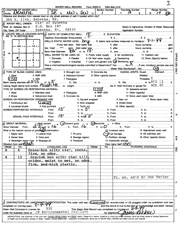
Specific Water Well Detail |
|
|
| Location Info | |||
| Owner: City of Sabetha | Status: Constructed | ||
| Location: T2S, R14E, Sec. 1, SE NW SW | County: Nemaha | ||
| Directions: 304 N. 11th, Sabetha | |||
| Latitude: 39.9042492 | Longitude: -95.8033267 | Datum NAD 27 | |
| Latitude: 39.9042493 | Longitude: -95.8035938 | Datum NAD 83 | |
| Longitude and latitude calculated by Survey from township-range-section-quarter calls. Only good to within the quarter call accuracy. | |||
| View well on interactive map | |||
| General Info | ||
| Well Depth: 13 ft. | Elevation: ft. | |
| Static Water Level: 0 ft. | Est. Yield: gpm. | |
| Comp. Date: 09-Feb-1999 | Well Use: Monitoring well/observation/piezometer | |
| DWR Applic. #: | Other ID: MW 7 | |
| Driller Info | ||
| Driller: JB Environmental Drilling | License #: 539 | |
| Scanned Form | View scan |
|
Chemical Sample Submitted?:
Water Well disinfected?: | ||
| Casing Info | ||
| Casing Type:
Casing Joints: |
Diam: in. to ft | |
| Casing height above land surface: in
Casing Weight: lbs/ft Wall thickness or gauge no.: | ||
| Screen and Perforation Info | ||
| Screen Type: | Screen Openings: | |
| Screen-perforated intervals | From: ft to ft | |
| Gravel pack intervals | From: ft to ft | |
| Grout Info | ||
| Grout used: | From: to ft | |
| Source of Possible Contamination | ||
| Source: | ||
| Direction from well: | Distance: ft | |
| Lithologic Log
(Log data entered by KGS.) | ||
| From: 0 ft. to 4 ft. | grass, brown silty clay, roots, firm, no odor | |
| From: 4 ft. to 13 ft. | grayish brown silty clay till, oxides, moist ro wet, no odor, firm, medium-high plastic | |