|
|
|
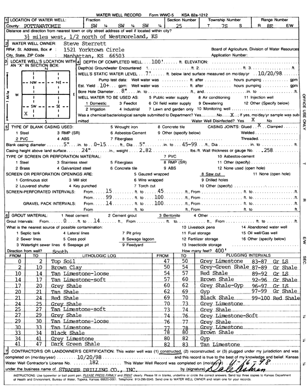
Specific Water Well Detail |
|
|
| Location Info | |||
| Owner: Sterrett, Steve | Status: Constructed | ||
| Location: T7S, R8E, Sec. 25, SW SW SW | County: Pottawatomie | ||
| Directions: from Westmoreland: 3.5 mi W, .5 mi N | |||
| Latitude: 39.4075867 | Longitude: -96.4808813 | Datum NAD 27 | |
| Latitude: 39.4075832 | Longitude: -96.4811635 | Datum NAD 83 | |
| Longitude and latitude calculated by Survey from township-range-section-quarter calls. Only good to within the quarter call accuracy. | |||
| View well on interactive map | |||
| General Info | ||
| Well Depth: 100 ft. | Elevation: ft. | |
| Static Water Level: 7 ft. | Est. Yield: 10 gpm. | |
| Comp. Date: 20-Oct-1998 | Well Use: Domestic | |
| DWR Applic. #: | Other ID: | |
| Driller Info | ||
| Driller: Strader Drilling Co., Inc. | License #: 182 | |
| Scanned Form | View scan |
|
Chemical Sample Submitted?:
Water Well disinfected?: | ||
| Casing Info | ||
| Casing Type:
Casing Joints: |
Diam: in. to ft | |
| Casing height above land surface: in
Casing Weight: lbs/ft Wall thickness or gauge no.: | ||
| Screen and Perforation Info | ||
| Screen Type: | Screen Openings: | |
| Screen-perforated intervals | From: ft to ft | |
| Gravel pack intervals | From: ft to ft | |
| Grout Info | ||
| Grout used: | From: to ft | |
| Source of Possible Contamination | ||
| Source: | ||
| Direction from well: | Distance: ft | |
| Lithologic Log
(Log data entered by KGS.) | ||
| From: 0 ft. to 2 ft. | top soil | |
| From: 2 ft. to 10 ft. | brown clay | |
| From: 10 ft. to 14 ft. | tan limestone, loose | |
| From: 14 ft. to 17 ft. | tan limestone, soft | |
| From: 17 ft. to 20 ft. | gray shale | |
| From: 20 ft. to 21 ft. | tan shale | |
| From: 21 ft. to 24 ft. | red shale | |
| From: 24 ft. to 25 ft. | gray shale | |
| From: 25 ft. to 27 ft. | tan limestone, soft | |
| From: 27 ft. to 29 ft. | gray shale | |
| From: 29 ft. to 30 ft. | tan limestone, loose | |
| From: 30 ft. to 33 ft. | tan limestone | |
| From: 33 ft. to 34 ft. | black shale | |
| From: 34 ft. to 41 ft. | gray limestone | |
| From: 41 ft. to 47 ft. | dark green shale | |
| From: 47 ft. to 50 ft. | gray limestone | |
| From: 50 ft. to 54 ft. | gray-green shale | |
| From: 54 ft. to 57 ft. | red shale | |
| From: 57 ft. to 60 ft. | brown shale | |
| From: 60 ft. to 62 ft. | gray shale, gypsum | |
| From: 62 ft. to 69 ft. | gypsum | |
| From: 69 ft. to 70 ft. | black shale | |
| From: 70 ft. to 73 ft. | gray limestone | |
| From: 73 ft. to 74 ft. | gray shale | |
| From: 74 ft. to 76 ft. | gray limestone, soft | |
| From: 76 ft. to 77 ft. | gray shale | |
| From: 77 ft. to 78 ft. | gray limestone | |
| From: 78 ft. to 80 ft. | brown shale | |
| From: 80 ft. to 82 ft. | gypsum | |
| From: 82 ft. to 83 ft. | tan limestone | |
| From: 83 ft. to 87 ft. | gray limestone | |
| From: 87 ft. to 89 ft. | gray shale | |
| From: 89 ft. to 92 ft. | gray limestone | |
| From: 92 ft. to 96 ft. | gray shale | |
| From: 96 ft. to 97 ft. | gray limestone | |
| From: 97 ft. to 99 ft. | gray shale | |
| From: 99 ft. to 100 ft. | red shale | |