|
|
|
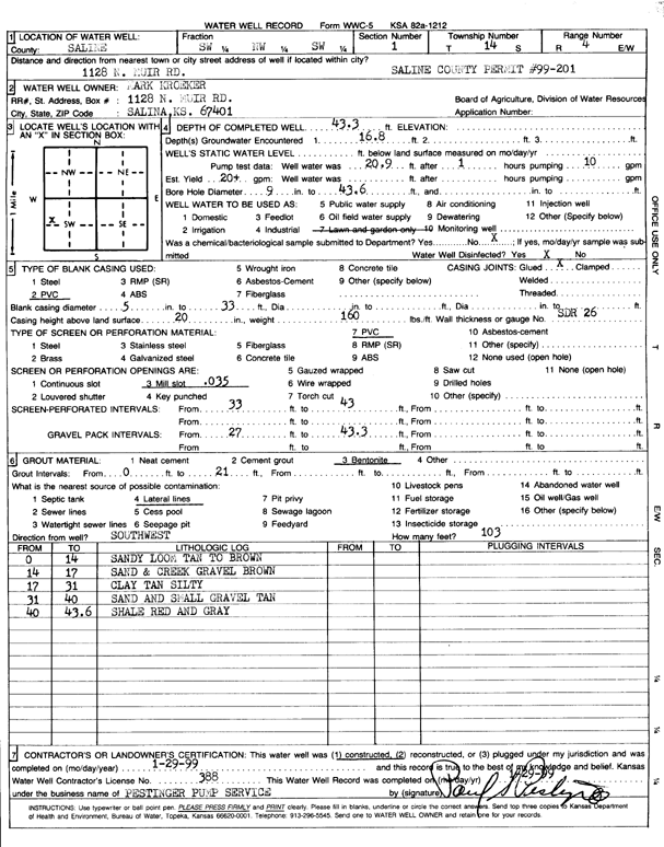
Specific Water Well Detail |
|
|
| Location Info | |||
| Owner: Kroeker, Mark | Status: Constructed | ||
| Location: T14S, R4W, Sec. 1, SW NW SW | County: Saline | ||
| Directions: 1128 N. Muir Road, Salina | |||
| Latitude: 38.8608736 | Longitude: -97.7228787 | Datum NAD 27 | |
| Latitude: 38.8608771 | Longitude: -97.7231946 | Datum NAD 83 | |
| Longitude and latitude calculated by Survey from township-range-section-quarter calls. Only good to within the quarter call accuracy. | |||
| View well on interactive map | |||
| General Info | ||
| Well Depth: 43.3 ft. | Elevation: ft. | |
| Static Water Level: ft. | Est. Yield: 20 gpm. | |
| Comp. Date: 29-Jan-1999 | Well Use: Domestic, Lawn and Garden | |
| DWR Applic. #: SA 99-201 | Other ID: | |
| Driller Info | ||
| Driller: Pestinger Pump Service | License #: 388 | |
| Scanned Form | View scan |
|
Chemical Sample Submitted?:
Water Well disinfected?: | ||
| Casing Info | ||
| Casing Type:
Casing Joints: |
Diam: in. to ft | |
| Casing height above land surface: in
Casing Weight: lbs/ft Wall thickness or gauge no.: | ||
| Screen and Perforation Info | ||
| Screen Type: | Screen Openings: | |
| Screen-perforated intervals | From: ft to ft | |
| Gravel pack intervals | From: ft to ft | |
| Grout Info | ||
| Grout used: | From: to ft | |
| Source of Possible Contamination | ||
| Source: | ||
| Direction from well: | Distance: ft | |
| Lithologic Log
(Log data entered by KGS.) | ||
| From: 0 ft. to 14 ft. | sandy loam, tan to brown | |
| From: 14 ft. to 17 ft. | sand and creek gravel, brown | |
| From: 17 ft. to 31 ft. | silty clay, tan | |
| From: 31 ft. to 40 ft. | sand and small gravel, tan | |
| From: 40 ft. to 43.6 ft. | shale, red and gray | |