|
|
|
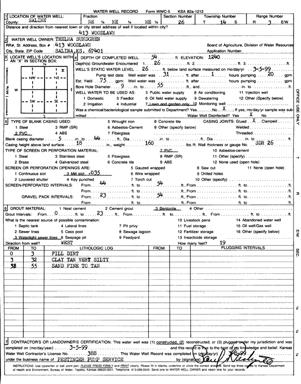
Specific Water Well Detail |
|
|
| Location Info | |||
| Owner: Sundgren, Thelma | Status: Constructed | ||
| Location: T14S, R3W, Sec. 23, SE SW SE SE | County: Saline | ||
| Directions: 413 Woodlawn, Salina | |||
| Latitude: 38.8133894 | Longitude: -97.6154945 | Datum NAD 27 | |
| Latitude: 38.813394 | Longitude: -97.615808 | Datum NAD 83 | |
| Longitude and latitude from GPS measurements. | |||
| GPS Latitude: 38.813394 | GPS Longitude: -97.615808 | Datum WGS84 | |
| View well on interactive map | |||
| General Info | ||
| Well Depth: 54 ft. | Elevation: 1240 ft. | |
| Static Water Level: 26 ft. | Est. Yield: 75 gpm. | |
| Comp. Date: 05-Mar-1999 | Well Use: Domestic, Lawn and Garden | |
| DWR Applic. #: | Other ID: | |
| Driller Info | ||
| Driller: Pestinger Pump Service | License #: 388 | |
| Scanned Form | View scan |
|
Chemical Sample Submitted?:
Water Well disinfected?: | ||
| Casing Info | ||
| Casing Type:
Casing Joints: |
Diam: in. to ft | |
| Casing height above land surface: in
Casing Weight: lbs/ft Wall thickness or gauge no.: | ||
| Screen and Perforation Info | ||
| Screen Type: | Screen Openings: | |
| Screen-perforated intervals | From: ft to ft | |
| Gravel pack intervals | From: ft to ft | |
| Grout Info | ||
| Grout used: | From: to ft | |
| Source of Possible Contamination | ||
| Source: | ||
| Direction from well: | Distance: ft | |
| Lithologic Log
(Log data entered by KGS.) | ||
| From: 0 ft. to 3 ft. | fill dirt | |
| From: 3 ft. to 32 ft. | very silty clay, tan | |
| From: 32 ft. to 55 ft. | fine sand, tran | |