|
|
|
Specific Water Well Detail |
|
|
| Location Info | |||
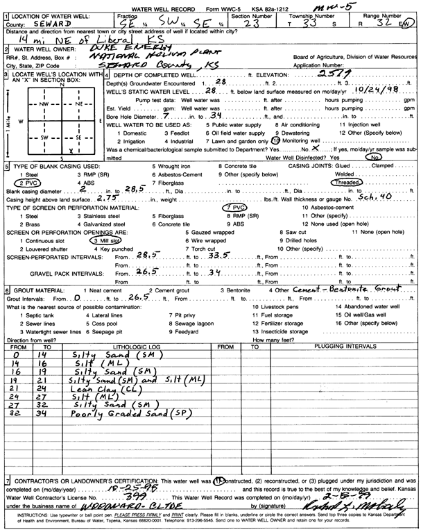
| Owner: Duke Energy | Status: Constructed | ||
| Location: T33S, R32W, Sec. 23, SE SW SE | County: Seward | ||
| Directions: from Liberal: 14 mi NE | |||
| Latitude: 37.1561535 | Longitude: -100.7654642 | Datum NAD 27 | |
| Latitude: 37.1561754 | Longitude: -100.7659004 | Datum NAD 83 | |
| Longitude and latitude calculated by Survey from township-range-section-quarter calls. Only good to within the quarter call accuracy. | |||
| View well on interactive map | |||
| General Info | ||
| Well Depth: 34 ft. | Elevation: 2579 ft. | |
| Static Water Level: 28 ft. | Est. Yield: gpm. | |
| Comp. Date: 25-Oct-1998 | Well Use: Monitoring well/observation/piezometer | |
| DWR Applic. #: | Other ID: MW 5 | |
| Driller Info | ||
| Driller: Woodward-Clyde | License #: 399 | |
| Scanned Form | View scan |
|
Chemical Sample Submitted?:
Water Well disinfected?: | ||
| Casing Info | ||
| Casing Type:
Casing Joints: |
Diam: in. to ft | |
| Casing height above land surface: in
Casing Weight: lbs/ft Wall thickness or gauge no.: | ||
| Screen and Perforation Info | ||
| Screen Type: | Screen Openings: | |
| Screen-perforated intervals | From: ft to ft | |
| Gravel pack intervals | From: ft to ft | |
| Grout Info | ||
| Grout used: | From: to ft | |
| Source of Possible Contamination | ||
| Source: | ||
| Direction from well: | Distance: ft | |
| Lithologic Log
(Log data entered by KGS.) | ||
| From: 0 ft. to 14 ft. | silty sand (sm) | |
| From: 14 ft. to 16 ft. | silt (ml) | |
| From: 16 ft. to 19 ft. | silty sand (sm) | |
| From: 19 ft. to 21 ft. | silty sand (sm) and silt (ml) | |
| From: 21 ft. to 24 ft. | lean clay (cl) | |
| From: 24 ft. to 27 ft. | silt (ml) | |
| From: 27 ft. to 32 ft. | silty sand (sm) | |
| From: 32 ft. to 34 ft. | poorly graded sand (sp) | |