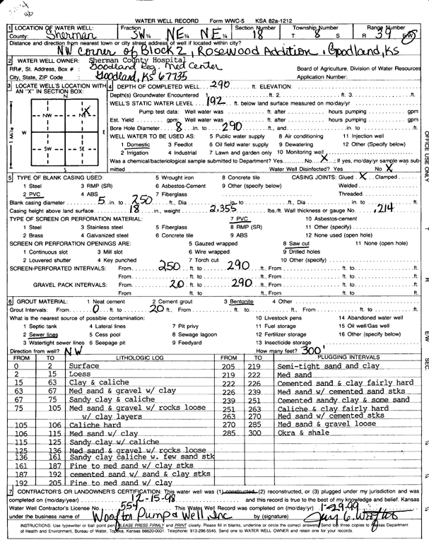
![]() |
![]() |
Specific Water Well Detail |
![]() |
Location Info | |||
Owner: Sherman County Hospital | Status: Constructed | ||
Location: T8S, R39W, Sec. 18, SW NE NE | County: Sherman | ||
Directions: NW corner of Block 2, Rosewood Addition, Goodland | |||
Latitude: 39.3630017 | Longitude: -101.7104175 | Datum NAD 27 | |
Latitude: 39.3630012 | Longitude: -101.7108675 | Datum NAD 83 | |
Longitude and latitude calculated by Survey from township-range-section-quarter calls. Only good to within the quarter call accuracy. | |||
View well on interactive map This link will create a new window and display an interactive map of this well and its neighbors. |
General Info | ||
Well Depth: 290 ft. | Elevation: ft. | |
Static Water Level: 192 ft. | Est. Yield: gpm. | |
Comp. Date: 15-Dec-1998 | Well Use: Domestic | |
DWR Applic. #: | Other ID: |
Driller Info | ||
Driller: Woofter Pump & Well, Inc. | License #: 554 |
Scanned Form | ||
View form(s) on screen | Download scan(s) | |
The download files contain one or more TIFF images compressed into a ZIP archive. Your browser may be already set up to decompress these files. The TIFFs are 300 dpi archival-quality scans of the WWC5 forms and can be viewed by software like Adobe PhotoShop. |
Chemical Sample Submitted?:
Water Well disinfected?: | ||
Casing Info | ||
Casing Type:
Casing Joints: |
Diam: in. to ft | |
Casing height above land surface: in
Casing Weight: lbs/ft Wall thickness or gauge no.: |
Screen and Perforation Info | ||
Screen Type: | Screen Openings: | |
Screen-perforated intervals | From: ft to ft | |
Gravel pack intervals | From: ft to ft |
Grout Info | ||
Grout used: | From: to ft |
Source of Possible Contamination | ||
Source: | ||
Direction from well: | Distance: ft |
Lithologic Log
(Log data entered by KGS.) | ||
From: 0 ft. to 2 ft. | Surface | |
From: 2 ft. to 15 ft. | Loess | |
From: 15 ft. to 63 ft. | Clay and caliche | |
From: 63 ft. to 67 ft. | Medium sand and gravel with clay | |
From: 67 ft. to 75 ft. | Sandy clay and caliche | |
From: 75 ft. to 105 ft. | Medium sand and gravel with rocks, loose, with clay layers | |
From: 105 ft. to 106 ft. | Caliche hard | |
From: 106 ft. to 115 ft. | Medium sand with clay | |
From: 115 ft. to 125 ft. | Sandy clay with caliche | |
From: 125 ft. to 136 ft. | Medium sand and gravel with rocks, loose | |
From: 136 ft. to 161 ft. | Sandy clay, caliche, with few sand streaks | |
From: 161 ft. to 187 ft. | Fine to medium sand with clay streaks | |
From: 187 ft. to 192 ft. | Cemented sand with sand and clay streaks | |
From: 192 ft. to 205 ft. | Fine to medium sand with clay | |
From: 205 ft. to 219 ft. | Semi-tight sand and clay | |
From: 219 ft. to 222 ft. | Medium sand | |
From: 222 ft. to 226 ft. | Cemented sand and clay, fairly hard | |
From: 226 ft. to 239 ft. | Medium sand with cemented sand streaks | |
From: 239 ft. to 251 ft. | Cemented sandy clay and some sand | |
From: 251 ft. to 263 ft. | Caliche and clay, fairly hard | |
From: 263 ft. to 270 ft. | Medium sand with cemented streaks | |
From: 270 ft. to 285 ft. | Medium sand and gravel, loose | |
From: 285 ft. to 300 ft. | Ochre and shale |