|
|
|
Specific Water Well Detail |
|
|
| Location Info | |||
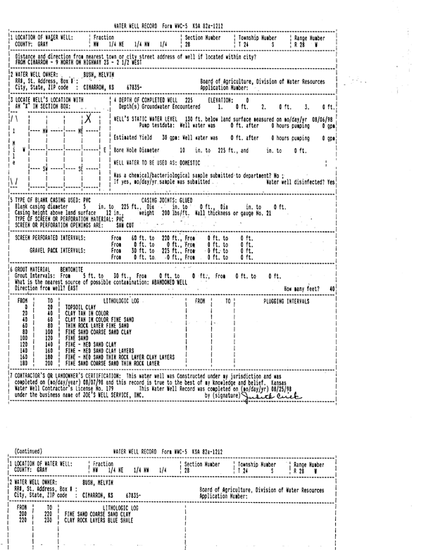
| Owner: Bush, Melvin | Status: Constructed | ||
| Location: T24S, R28W, Sec. 28, NW NE NW | County: Gray | ||
| Directions: from Cimarron: 9 mi N on Hwy 23, 2.5 mi W | |||
| Latitude: 37.9422262 | Longitude: -100.4036788 | Datum NAD 27 | |
| Latitude: 37.9422469 | Longitude: -100.4041018 | Datum NAD 83 | |
| Longitude and latitude calculated by Survey from township-range-section-quarter calls. Only good to within the quarter call accuracy. | |||
| View well on interactive map | |||
| General Info | ||
| Well Depth: 225 ft. | Elevation: ft. | |
| Static Water Level: 130 ft. | Est. Yield: 30 gpm. | |
| Comp. Date: 07-Aug-1998 | Well Use: Domestic | |
| DWR Applic. #: | Other ID: | |
| Driller Info | ||
| Driller: Joe's Well Service, Inc. | License #: 179 | |
| Scanned Form | View scan |
|
Chemical Sample Submitted?:
Water Well disinfected?: | ||
| Casing Info | ||
| Casing Type:
Casing Joints: |
Diam: in. to ft | |
| Casing height above land surface: in
Casing Weight: lbs/ft Wall thickness or gauge no.: | ||
| Screen and Perforation Info | ||
| Screen Type: | Screen Openings: | |
| Screen-perforated intervals | From: ft to ft | |
| Gravel pack intervals | From: ft to ft | |
| Grout Info | ||
| Grout used: | From: to ft | |
| Source of Possible Contamination | ||
| Source: | ||
| Direction from well: | Distance: ft | |
| Lithologic Log
(Log data entered by KGS.) | ||
| From: 0 ft. to 20 ft. | TOPSOIL CLAY | |
| From: 20 ft. to 40 ft. | CLAY TAN IN COLOR | |
| From: 40 ft. to 60 ft. | CLAY TAN IN COLOR FINE SAND | |
| From: 60 ft. to 80 ft. | THIN ROCK LAYER FINE SAND | |
| From: 80 ft. to 100 ft. | FINE SAND COARSE SAND CLAY | |
| From: 100 ft. to 120 ft. | FINE SAND | |
| From: 120 ft. to 140 ft. | FINE TO MEDIUM SAND CLAY | |
| From: 140 ft. to 160 ft. | FINE TO MEDIUM SAND CLAY LAYERS | |
| From: 160 ft. to 180 ft. | FINE TO MEDIUM SAND THIN ROCK LAYER CLAY LAYERS | |
| From: 180 ft. to 200 ft. | FINE SAND COARSE SAND THIN ROCK LAYER | |
| From: 200 ft. to 220 ft. | FINE SAND COARSE SAND CLAY | |
| From: 220 ft. to 230 ft. | CLAY ROCK LAYERS | |