|
|
|
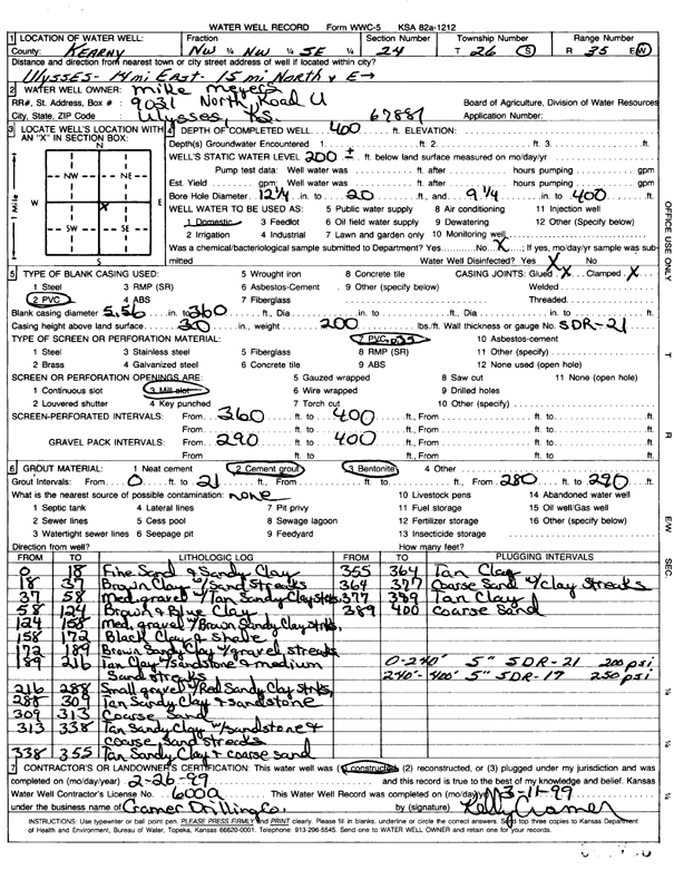
Specific Water Well Detail |
|
|
| Location Info | |||
| Owner: Meyers, Mike | Status: Constructed | ||
| Location: T26S, R35W, Sec. 24, NW NW SE | County: Kearny | ||
| Directions: from Ulysses: 14 mi E, 15 mi N, E into site | |||
| Latitude: 37.7720646 | Longitude: -101.0971708 | Datum NAD 27 | |
| Latitude: 37.7720863 | Longitude: -101.0976186 | Datum NAD 83 | |
| Longitude and latitude calculated by Survey from township-range-section-quarter calls. Only good to within the quarter call accuracy. | |||
| View well on interactive map | |||
| General Info | ||
| Well Depth: 400 ft. | Elevation: ft. | |
| Static Water Level: 200 ft. | Est. Yield: gpm. | |
| Comp. Date: 26-Feb-1999 | Well Use: Domestic | |
| DWR Applic. #: | Other ID: | |
| Driller Info | ||
| Driller: Ray Cramer Drilling Co. | License #: 600 | |
| Scanned Form | View scan |
|
Chemical Sample Submitted?:
Water Well disinfected?: | ||
| Casing Info | ||
| Casing Type:
Casing Joints: |
Diam: in. to ft | |
| Casing height above land surface: in
Casing Weight: lbs/ft Wall thickness or gauge no.: | ||
| Screen and Perforation Info | ||
| Screen Type: | Screen Openings: | |
| Screen-perforated intervals | From: ft to ft | |
| Gravel pack intervals | From: ft to ft | |
| Grout Info | ||
| Grout used: | From: to ft | |
| Source of Possible Contamination | ||
| Source: | ||
| Direction from well: | Distance: ft | |
| Lithologic Log
(Log data entered by KGS.) | ||
| From: 0 ft. to 18 ft. | fine sand and sandy clay | |
| From: 18 ft. to 37 ft. | brown clay with sand streaks | |
| From: 37 ft. to 58 ft. | medium gravel with tan sandy clay streaks | |
| From: 58 ft. to 124 ft. | brown and blue clay | |
| From: 124 ft. to 158 ft. | medium gravel with brown sandy clay streaks | |
| From: 158 ft. to 172 ft. | black clay and shale | |
| From: 172 ft. to 189 ft. | brown sandy clay with gravel streaks | |
| From: 189 ft. to 216 ft. | tan clay with sandstone and medium sand streaks | |
| From: 216 ft. to 288 ft. | small gravel with red sandy clay streaks | |
| From: 288 ft. to 309 ft. | tan sandy clay and sandstone | |
| From: 309 ft. to 313 ft. | coarse sand | |
| From: 313 ft. to 338 ft. | tan sandy clay with sandstone and coarse sand streaks | |
| From: 338 ft. to 355 ft. | tan sandy clay and coarse sand | |
| From: 355 ft. to 364 ft. | tan clay | |
| From: 364 ft. to 377 ft. | coarse sand with clay streaks | |
| From: 377 ft. to 389 ft. | tan clay | |
| From: 389 ft. to 400 ft. | coarse sand | |