|
|
|
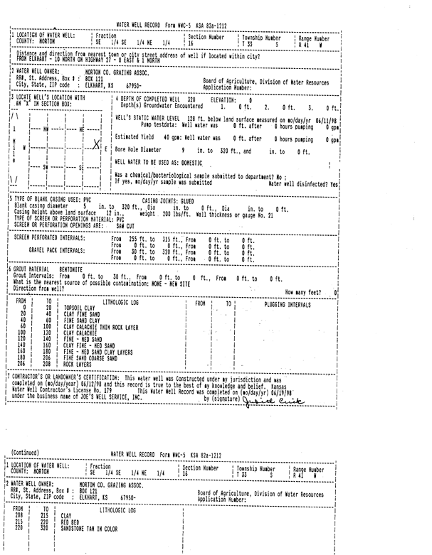
Specific Water Well Detail |
|
|
| Location Info | |||
| Owner: Morton County Grazing Assoc. | Status: Constructed | ||
| Location: T33S, R41W, Sec. 16, SE SE NE | County: Morton | ||
| Directions: from Elkhart, 10 mi N on Hwy 27, 8 mi E, and 1 mi N | |||
| Latitude: 37.1789463 | Longitude: -101.7741223 | Datum NAD 27 | |
| Latitude: 37.1789702 | Longitude: -101.774565 | Datum NAD 83 | |
| Longitude and latitude calculated by Survey from township-range-section-quarter calls. Only good to within the quarter call accuracy. | |||
| View well on interactive map | |||
| General Info | ||
| Well Depth: 320 ft. | Elevation: ft. | |
| Static Water Level: 128 ft. | Est. Yield: 40 gpm. | |
| Comp. Date: 12-Jun-1998 | Well Use: Domestic | |
| DWR Applic. #: | Other ID: | |
| Driller Info | ||
| Driller: Joe's Well Service, Inc. | License #: 179 | |
| Scanned Form | View scan |
|
Chemical Sample Submitted?:
Water Well disinfected?: | ||
| Casing Info | ||
| Casing Type:
Casing Joints: |
Diam: in. to ft | |
| Casing height above land surface: in
Casing Weight: lbs/ft Wall thickness or gauge no.: | ||
| Screen and Perforation Info | ||
| Screen Type: | Screen Openings: | |
| Screen-perforated intervals | From: ft to ft | |
| Gravel pack intervals | From: ft to ft | |
| Grout Info | ||
| Grout used: | From: to ft | |
| Source of Possible Contamination | ||
| Source: | ||
| Direction from well: | Distance: ft | |
| Lithologic Log
(Log data entered by KGS.) | ||
| From: 0 ft. to 20 ft. | topsoil, clay | |
| From: 20 ft. to 40 ft. | clay, fine sand | |
| From: 40 ft. to 60 ft. | fine sand, clay | |
| From: 60 ft. to 100 ft. | clay, caliche, thin rock layer | |
| From: 100 ft. to 120 ft. | clay, caliche | |
| From: 120 ft. to 140 ft. | fine-medium sand | |
| From: 140 ft. to 160 ft. | clay, fine-medium sand | |
| From: 160 ft. to 180 ft. | fine-medium sand, clay layers | |
| From: 180 ft. to 206 ft. | fine sand, coarse sand | |
| From: 206 ft. to 208 ft. | rock layers | |
| From: 208 ft. to 215 ft. | clay | |
| From: 215 ft. to 220 ft. | red bed | |
| From: 220 ft. to 320 ft. | sandstone tan in color | |