|
|
|
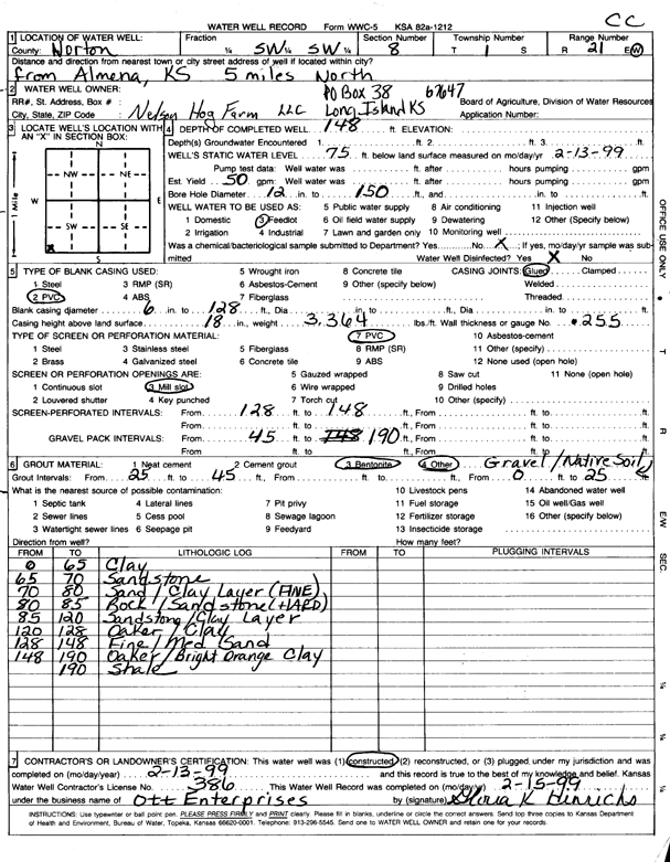
Specific Water Well Detail |
|
|
| Location Info | |||
| Owner: Nelson Hog Farm | Status: Constructed | ||
| Location: T1S, R21W, Sec. 8, SW SW | County: Norton | ||
| Directions: from Almena, 5 mi N | |||
| Latitude: 39.9744116 | Longitude: -99.7172 | Datum NAD 27 | |
| Latitude: 39.9744192 | Longitude: -99.7175918 | Datum NAD 83 | |
| Longitude and latitude calculated by Survey from township-range-section-quarter calls. Only good to within the quarter call accuracy. | |||
| View well on interactive map | |||
| General Info | ||
| Well Depth: 148 ft. | Elevation: ft. | |
| Static Water Level: 75 ft. | Est. Yield: gpm. | |
| Comp. Date: 13-Feb-1999 | Well Use: Feedlot | |
| DWR Applic. #: | Other ID: | |
| Links | |
| No Wizard information available. | |
| View info from WIMAS Water Right Data base... | |
| Driller Info | ||
| Driller: Paul Ott Enterprises | License #: 386 | |
| Scanned Form | View scan |
|
Chemical Sample Submitted?:
Water Well disinfected?: | ||
| Casing Info | ||
| Casing Type:
Casing Joints: |
Diam: in. to ft | |
| Casing height above land surface: in
Casing Weight: lbs/ft Wall thickness or gauge no.: | ||
| Screen and Perforation Info | ||
| Screen Type: | Screen Openings: | |
| Screen-perforated intervals | From: ft to ft | |
| Gravel pack intervals | From: ft to ft | |
| Grout Info | ||
| Grout used: | From: to ft | |
| Source of Possible Contamination | ||
| Source: | ||
| Direction from well: | Distance: ft | |
| Lithologic Log
(Log data entered by KGS.) | ||
| From: 0 ft. to 65 ft. | clay | |
| From: 65 ft. to 70 ft. | sandstone | |
| From: 70 ft. to 80 ft. | sand, clay layer (fine) | |
| From: 80 ft. to 85 ft. | rock/sandstone (hard) | |
| From: 85 ft. to 120 ft. | sandstone/clay layer | |
| From: 120 ft. to 128 ft. | ochre/clay | |
| From: 128 ft. to 148 ft. | fine/medium sand | |
| From: 148 ft. to 190 ft. | ochre/bright orange clay | |
| From: ft. to 190 ft. | shale | |