|
|
|
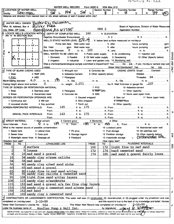
Specific Water Well Detail |
|
|
| Location Info | |||
| Owner: Butterfly Aviation | Status: Constructed | ||
| Location: T8S, R39W, Sec. 8, SW NW SW | County: Sherman | ||
| Directions: | |||
| Latitude: 39.3702997 | Longitude: -101.7058721 | Datum NAD 27 | |
| Latitude: 39.3702991 | Longitude: -101.706322 | Datum NAD 83 | |
| Longitude and latitude calculated by Survey from township-range-section-quarter calls. Only good to within the quarter call accuracy. | |||
| View well on interactive map | |||
| General Info | ||
| Well Depth: 180 ft. | Elevation: ft. | |
| Static Water Level: 159.14 ft. | Est. Yield: gpm. | |
| Comp. Date: 10-Feb-1999 | Well Use: Monitoring well/observation/piezometer | |
| DWR Applic. #: | Other ID: MW 2 | |
| Driller Info | ||
| Driller: Woofter Pump & Well, Inc. | License #: 554 | |
| Scanned Form | View scan |
|
Chemical Sample Submitted?:
Water Well disinfected?: | ||
| Casing Info | ||
| Casing Type:
Casing Joints: |
Diam: in. to ft | |
| Casing height above land surface: in
Casing Weight: lbs/ft Wall thickness or gauge no.: | ||
| Screen and Perforation Info | ||
| Screen Type: | Screen Openings: | |
| Screen-perforated intervals | From: ft to ft | |
| Gravel pack intervals | From: ft to ft | |
| Grout Info | ||
| Grout used: | From: to ft | |
| Source of Possible Contamination | ||
| Source: | ||
| Direction from well: | Distance: ft | |
| Lithologic Log
(Log data entered by KGS.) | ||
| From: 0 ft. to 2 ft. | Surface | |
| From: 2 ft. to 9 ft. | Loess | |
| From: 9 ft. to 18 ft. | Medium sand and gravel | |
| From: 18 ft. to 54 ft. | Sandy clay with some caliche | |
| From: 54 ft. to 58 ft. | Medium sand | |
| From: 58 ft. to 60 ft. | Sandy clay with medium sand streaks | |
| From: 60 ft. to 65 ft. | Medium sand and gravel | |
| From: 65 ft. to 80 ft. | Tight fine to medium sand with clay | |
| From: 80 ft. to 95 ft. | Sandy clay, caliche, and cemented sand | |
| From: 95 ft. to 108 ft. | Tight fine sand with clay layers | |
| From: 108 ft. to 115 ft. | Sandy clay with sand streaks | |
| From: 115 ft. to 153 ft. | Medium sand and gravel with a few fine clay layers | |
| From: 153 ft. to 159 ft. | Sandy clay and cemented sand with some sand | |
| From: 159 ft. to 162 ft. | Medium sand | |
| From: 162 ft. to 166 ft. | Sandy clay and cemented sand | |
| From: 166 ft. to 172 ft. | Tight fine to medium sand | |
| From: 172 ft. to 174 ft. | Hard cemented sand | |
| From: 174 ft. to 180 ft. | Medium sand and gravel, fairly loose | |