|
|
|
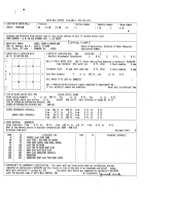
Specific Water Well Detail |
|
|
| Location Info | |||
| Owner: Jerry Jones and Ron Grover | Status: Constructed | ||
| Location: T29S, R42W, Sec. 5, NE SW NW | County: Stanton | ||
| Directions: From Johnson, 11 miles West on old highway 160 and 1.5 miles South | |||
| Latitude: 37.5592768 | Longitude: -101.9395967 | Datum NAD 27 | |
| Latitude: 37.5592928 | Longitude: -101.9400501 | Datum NAD 83 | |
| Longitude and latitude calculated by Survey from township-range-section-quarter calls. Only good to within the quarter call accuracy. | |||
| View well on interactive map | |||
| General Info | ||
| Well Depth: 285 ft. | Elevation: ft. | |
| Static Water Level: 148 ft. | Est. Yield: 35 gpm. | |
| Comp. Date: 04-Jun-1998 | Well Use: Other | |
| DWR Applic. #: | Other ID: | |
| Driller Info | ||
| Driller: Joe's Well Service, Inc. | License #: 179 | |
| Scanned Form | View scan |
|
Chemical Sample Submitted?:
Water Well disinfected?: | ||
| Casing Info | ||
| Casing Type:
Casing Joints: |
Diam: in. to ft | |
| Casing height above land surface: in
Casing Weight: lbs/ft Wall thickness or gauge no.: | ||
| Screen and Perforation Info | ||
| Screen Type: | Screen Openings: | |
| Screen-perforated intervals | From: ft to ft | |
| Gravel pack intervals | From: ft to ft | |
| Grout Info | ||
| Grout used: | From: to ft | |
| Source of Possible Contamination | ||
| Source: | ||
| Direction from well: | Distance: ft | |
| Lithologic Log
(Log data entered by KGS.) | ||
| From: 0 ft. to 20 ft. | topsoil clay fine sand | |
| From: 20 ft. to 60 ft. | clay fine - medium sand in layers | |
| From: 60 ft. to 75 ft. | fine sand coarse sand small gravel | |
| From: 75 ft. to 100 ft. | clay tan in color | |
| From: 100 ft. to 120 ft. | clay tan in color gray clay | |
| From: 120 ft. to 140 ft. | gray clay clay blue clay | |
| From: 140 ft. to 180 ft. | gray clay sandstone layer(s) | |
| From: 180 ft. to 280 ft. | sandstone | |
| From: 280 ft. to 300 ft. | sandstone gray clay thin rock layer | |