|
|
|
Specific Water Well Detail |
|
|
| Location Info | |||
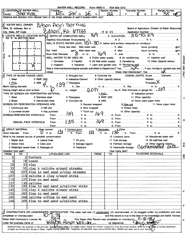
| Owner: Edson Agricultural Services | Status: Constructed | ||
| Location: T8S, R38W, Sec. 22, NE SW SE | County: Sherman | ||
| Directions: | |||
| Latitude: 39.3396984 | Longitude: -101.5455414 | Datum NAD 27 | |
| Latitude: 39.3396997 | Longitude: -101.5459865 | Datum NAD 83 | |
| Longitude and latitude calculated by Survey from township-range-section-quarter calls. Only good to within the quarter call accuracy. | |||
| View well on interactive map | |||
| General Info | ||
| Well Depth: 169 ft. | Elevation: 3570.29 ft. | |
| Static Water Level: 151.3 ft. | Est. Yield: gpm. | |
| Comp. Date: 07-Oct-1998 | Well Use: Monitoring well/observation/piezometer | |
| DWR Applic. #: | Other ID: MW 5 | |
| Driller Info | ||
| Driller: Woofter Pump & Well, Inc. | License #: 554 | |
| Scanned Form | View scan |
|
Chemical Sample Submitted?:
Water Well disinfected?: | ||
| Casing Info | ||
| Casing Type:
Casing Joints: |
Diam: in. to ft | |
| Casing height above land surface: in
Casing Weight: lbs/ft Wall thickness or gauge no.: | ||
| Screen and Perforation Info | ||
| Screen Type: | Screen Openings: | |
| Screen-perforated intervals | From: ft to ft | |
| Gravel pack intervals | From: ft to ft | |
| Grout Info | ||
| Grout used: | From: to ft | |
| Source of Possible Contamination | ||
| Source: | ||
| Direction from well: | Distance: ft | |
| Lithologic Log
(Log data entered by KGS.) | ||
| From: 0 ft. to 2 ft. | Surface | |
| From: 2 ft. to 18 ft. | Loess | |
| From: 18 ft. to 33 ft. | Clay | |
| From: 33 ft. to 55 ft. | Clay and caliche with sand streaks | |
| From: 55 ft. to 107 ft. | Fine to medium sand with clay streaks | |
| From: 107 ft. to 115 ft. | Fine to medium sand | |
| From: 115 ft. to 127 ft. | Fine to medium sand | |
| From: 127 ft. to 130 ft. | Caliche | |
| From: 130 ft. to 145 ft. | Fine to medium sand with caliche streaks | |
| From: 145 ft. to 152 ft. | Clay and caliche with sand streaks | |
| From: 152 ft. to 160 ft. | Fine to medium sand | |
| From: 160 ft. to 164 ft. | Caliche with fine to medium sand | |
| From: 164 ft. to 169 ft. | Fine to medium sand with caliche streaks | |