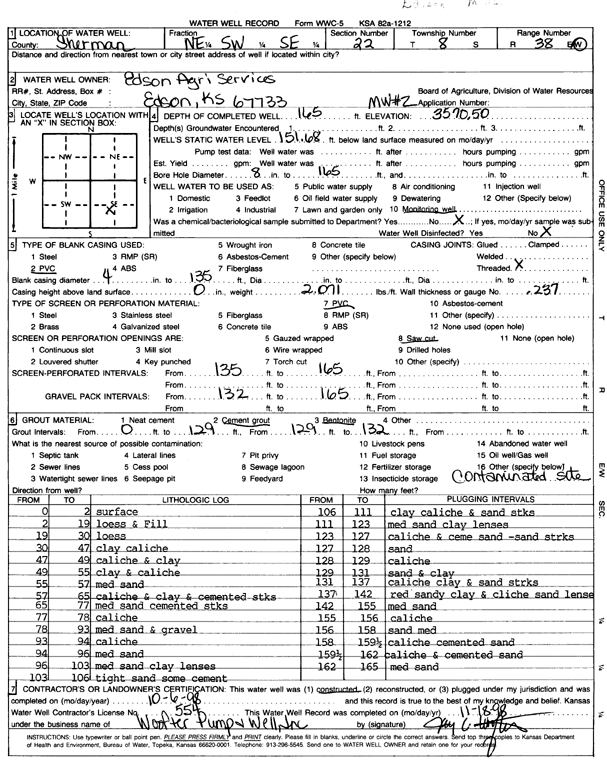
![]() |
![]() |
Specific Water Well Detail |
![]() |
Location Info | |||
Owner: Edson Agricultural Services | Status: Constructed | ||
Location: T8S, R38W, Sec. 22, NE SW SE | County: Sherman | ||
Directions: | |||
Latitude: 39.3396984 | Longitude: -101.5455414 | Datum NAD 27 | |
Latitude: 39.3396997 | Longitude: -101.5459865 | Datum NAD 83 | |
Longitude and latitude calculated by Survey from township-range-section-quarter calls. Only good to within the quarter call accuracy. | |||
View well on interactive map |
General Info | ||
Well Depth: 165 ft. | Elevation: 3570.5 ft. | |
Static Water Level: 151.68 ft. | Est. Yield: gpm. | |
Comp. Date: 06-Oct-1998 | Well Use: Monitoring well/observation/piezometer | |
DWR Applic. #: | Other ID: MW 2 |
Driller Info | ||
Driller: Woofter Pump & Well, Inc. | License #: 554 |
Scanned Form | ||
View form(s) on screen | Download scan(s) | |
The download files contain one or more TIFF images compressed into a ZIP archive. Your browser may be already set up to decompress these files. The TIFFs are 300 dpi archival-quality scans of the WWC5 forms and can be viewed by software like Adobe PhotoShop. |
Chemical Sample Submitted?:
Water Well disinfected?: | ||
Casing Info | ||
Casing Type:
Casing Joints: |
Diam: in. to ft | |
Casing height above land surface: in
Casing Weight: lbs/ft Wall thickness or gauge no.: |
Screen and Perforation Info | ||
Screen Type: | Screen Openings: | |
Screen-perforated intervals | From: ft to ft | |
Gravel pack intervals | From: ft to ft |
Grout Info | ||
Grout used: | From: to ft |
Source of Possible Contamination | ||
Source: | ||
Direction from well: | Distance: ft |
Lithologic Log
(Log data entered by KGS.) | ||
From: 0 ft. to 2 ft. | Surface | |
From: 2 ft. to 19 ft. | Loess and fill | |
From: 19 ft. to 30 ft. | Loess | |
From: 30 ft. to 47 ft. | Clay, caliche | |
From: 47 ft. to 49 ft. | Caliche and clay | |
From: 49 ft. to 55 ft. | Clay and caliche | |
From: 55 ft. to 57 ft. | Medium sand | |
From: 57 ft. to 65 ft. | Caliche and clay and cemented streaks | |
From: 65 ft. to 77 ft. | Medium sand, cemented streaks | |
From: 77 ft. to 78 ft. | Caliche | |
From: 78 ft. to 93 ft. | Medium sand and gravel | |
From: 93 ft. to 94 ft. | Caliche | |
From: 94 ft. to 96 ft. | Medium sand | |
From: 96 ft. to 103 ft. | Medium sand, clay lenses | |
From: 103 ft. to 106 ft. | Tight sand, some cement | |
From: 106 ft. to 111 ft. | Clay, caliche, and sand streaks | |
From: 111 ft. to 123 ft. | Medium sand, clay lenses | |
From: 123 ft. to 127 ft. | Caliche and cemented sand, sand streaks | |
From: 127 ft. to 128 ft. | Sand | |
From: 128 ft. to 129 ft. | Caliche | |
From: 129 ft. to 131 ft. | Sand and clay | |
From: 131 ft. to 137 ft. | Caliche clay and sand streaks | |
From: 137 ft. to 142 ft. | Red sandy clay and caliche sand lenses | |
From: 142 ft. to 155 ft. | Medium sand | |
From: 155 ft. to 156 ft. | Caliche | |
From: 156 ft. to 158 ft. | Sand, medium | |
From: 158 ft. to 159.5 ft. | Caliche, cemented sand | |
From: 159.5 ft. to 162 ft. | Caliche and cemented sand | |
From: 162 ft. to 165 ft. | Medium sand |