|
|
|
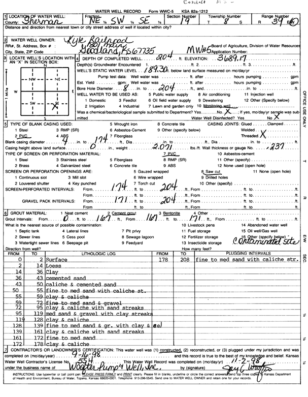
Specific Water Well Detail |
|
|
| Location Info | |||
| Owner: Kyle Railroad | Status: Constructed | ||
| Location: T8S, R39W, Sec. 19, NE SW SE | County: Sherman | ||
| Directions: 1801 Main, Goodland | |||
| Latitude: 39.3393994 | Longitude: -101.7127338 | Datum NAD 27 | |
| Latitude: 39.3393993 | Longitude: -101.7131839 | Datum NAD 83 | |
| Longitude and latitude calculated by Survey from township-range-section-quarter calls. Only good to within the quarter call accuracy. | |||
| View well on interactive map | |||
| General Info | ||
| Well Depth: 204 ft. | Elevation: 3689.17 ft. | |
| Static Water Level: 189.3 ft. | Est. Yield: gpm. | |
| Comp. Date: 16-Sep-1998 | Well Use: Monitoring well/observation/piezometer | |
| DWR Applic. #: | Other ID: MW 5 | |
| Driller Info | ||
| Driller: Woofter Pump & Well, Inc. | License #: 554 | |
| Scanned Form | View scan |
|
Chemical Sample Submitted?:
Water Well disinfected?: | ||
| Casing Info | ||
| Casing Type:
Casing Joints: |
Diam: in. to ft | |
| Casing height above land surface: in
Casing Weight: lbs/ft Wall thickness or gauge no.: | ||
| Screen and Perforation Info | ||
| Screen Type: | Screen Openings: | |
| Screen-perforated intervals | From: ft to ft | |
| Gravel pack intervals | From: ft to ft | |
| Grout Info | ||
| Grout used: | From: to ft | |
| Source of Possible Contamination | ||
| Source: | ||
| Direction from well: | Distance: ft | |
| Lithologic Log
(Log data entered by KGS.) | ||
| From: 0 ft. to 2 ft. | Surface | |
| From: 2 ft. to 14 ft. | Loess | |
| From: 14 ft. to 36 ft. | Clay | |
| From: 36 ft. to 43 ft. | Cemented sand | |
| From: 43 ft. to 50 ft. | Caliche and cemented sand | |
| From: 50 ft. to 55 ft. | Fine to medium sand with caliche streaks | |
| From: 55 ft. to 59 ft. | Clay and caliche | |
| From: 59 ft. to 72 ft. | Fine to medium sand and gravel | |
| From: 72 ft. to 95 ft. | Clay and caliche with sand streaks | |
| From: 95 ft. to 119 ft. | Medium sand and gravel with clay streaks | |
| From: 119 ft. to 128 ft. | Clay and caliche | |
| From: 128 ft. to 139 ft. | Fine to medium sand and gravel with clay and caliche | |
| From: 139 ft. to 161 ft. | Clay and caliche with sand streaks | |
| From: 161 ft. to 172 ft. | Fine to medium sand | |
| From: 172 ft. to 178 ft. | Clay and caliche | |
| From: 178 ft. to 208 ft. | Fine to medium sand with caliche streaks | |