|
|
|
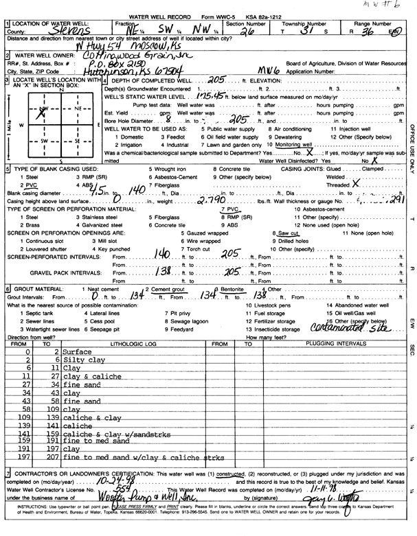
Specific Water Well Detail |
|
|
| Location Info | |||
| Owner: Collingwood Grain, Inc. | Status: Constructed | ||
| Location: T31S, R36W, Sec. 26, NE SW NW | County: Stevens | ||
| Directions: North Highway 54 in Moscow | |||
| Latitude: 37.3249534 | Longitude: -101.2087243 | Datum NAD 27 | |
| Latitude: 37.3249772 | Longitude: -101.2091629 | Datum NAD 83 | |
| Longitude and latitude calculated by Survey from township-range-section-quarter calls. Only good to within the quarter call accuracy. | |||
| View well on interactive map | |||
| General Info | ||
| Well Depth: 205 ft. | Elevation: ft. | |
| Static Water Level: 175.5 ft. | Est. Yield: gpm. | |
| Comp. Date: 24-Oct-1998 | Well Use: Monitoring well/observation/piezometer | |
| DWR Applic. #: | Other ID: MW 6 | |
| Driller Info | ||
| Driller: Woofter Pump & Well, Inc. | License #: 554 | |
| Scanned Form | View scan |
|
Chemical Sample Submitted?:
Water Well disinfected?: | ||
| Casing Info | ||
| Casing Type:
Casing Joints: |
Diam: in. to ft | |
| Casing height above land surface: in
Casing Weight: lbs/ft Wall thickness or gauge no.: | ||
| Screen and Perforation Info | ||
| Screen Type: | Screen Openings: | |
| Screen-perforated intervals | From: ft to ft | |
| Gravel pack intervals | From: ft to ft | |
| Grout Info | ||
| Grout used: | From: to ft | |
| Source of Possible Contamination | ||
| Source: | ||
| Direction from well: | Distance: ft | |
| Lithologic Log
(Log data entered by KGS.) | ||
| From: 0 ft. to 2 ft. | surface | |
| From: 2 ft. to 6 ft. | silty clay | |
| From: 6 ft. to 11 ft. | clay | |
| From: 11 ft. to 27 ft. | clay and caliche | |
| From: 27 ft. to 34 ft. | fine sand | |
| From: 34 ft. to 43 ft. | clay | |
| From: 43 ft. to 58 ft. | fine sand | |
| From: 58 ft. to 109 ft. | clay | |
| From: 109 ft. to 139 ft. | caliche and clay | |
| From: 139 ft. to 141 ft. | caliche | |
| From: 141 ft. to 159 ft. | caliche and clay with sand streaks | |
| From: 159 ft. to 191 ft. | fine to medium sand | |
| From: 191 ft. to 197 ft. | clay | |
| From: 197 ft. to 207 ft. | fine to medium sand with clay and caliche streaks | |