|
|
|
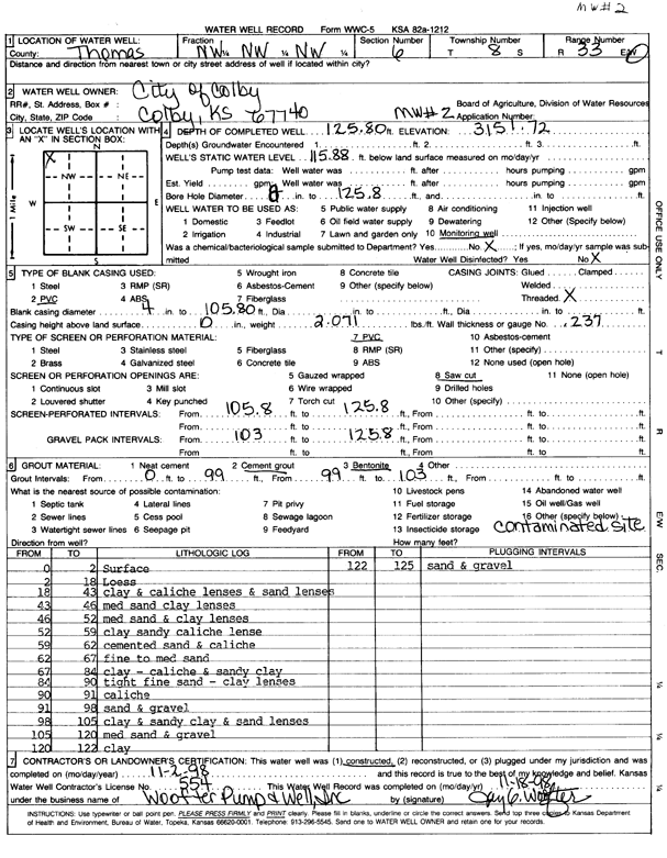
Specific Water Well Detail |
|
|
| Location Info | |||
| Owner: City of Colby | Status: Constructed | ||
| Location: T8S, R33W, Sec. 6, NW NW NW | County: Thomas | ||
| Directions: | |||
| Latitude: 39.3934057 | Longitude: -101.0531553 | Datum NAD 27 | |
| Latitude: 39.3934093 | Longitude: -101.0535882 | Datum NAD 83 | |
| Longitude and latitude calculated by Survey from township-range-section-quarter calls. Only good to within the quarter call accuracy. | |||
| View well on interactive map | |||
| General Info | ||
| Well Depth: 125.8 ft. | Elevation: 3151.72 ft. | |
| Static Water Level: 115.8 ft. | Est. Yield: gpm. | |
| Comp. Date: 02-Nov-1998 | Well Use: Monitoring well/observation/piezometer | |
| DWR Applic. #: | Other ID: MW 2 | |
| Driller Info | ||
| Driller: Woofter Pump & Well, Inc. | License #: 554 | |
| Scanned Form | View scan |
|
Chemical Sample Submitted?:
Water Well disinfected?: | ||
| Casing Info | ||
| Casing Type:
Casing Joints: |
Diam: in. to ft | |
| Casing height above land surface: in
Casing Weight: lbs/ft Wall thickness or gauge no.: | ||
| Screen and Perforation Info | ||
| Screen Type: | Screen Openings: | |
| Screen-perforated intervals | From: ft to ft | |
| Gravel pack intervals | From: ft to ft | |
| Grout Info | ||
| Grout used: | From: to ft | |
| Source of Possible Contamination | ||
| Source: | ||
| Direction from well: | Distance: ft | |
| Lithologic Log
(Log data entered by KGS.) | ||
| From: 0 ft. to 2 ft. | surface | |
| From: 2 ft. to 18 ft. | loess | |
| From: 18 ft. to 43 ft. | clay and caliche lenses and sand lenses | |
| From: 43 ft. to 46 ft. | medium sand and clay lenses | |
| From: 46 ft. to 52 ft. | medium sand and clay lenses | |
| From: 52 ft. to 59 ft. | clay, sandy, caliche lenses | |
| From: 59 ft. to 62 ft. | cemented sand and caliche | |
| From: 62 ft. to 67 ft. | fine to medium sand | |
| From: 67 ft. to 84 ft. | clay, caliche, and sandy clay | |
| From: 84 ft. to 90 ft. | tight fine sand, clay lenses | |
| From: 90 ft. to 91 ft. | caliche | |
| From: 91 ft. to 98 ft. | sand and gravel | |
| From: 98 ft. to 105 ft. | clay and sandy clay and sand lenses | |
| From: 105 ft. to 120 ft. | medium sand and gravel | |
| From: 120 ft. to 122 ft. | clay | |
| From: 122 ft. to 125 ft. | sand and gravel | |