|
|
|
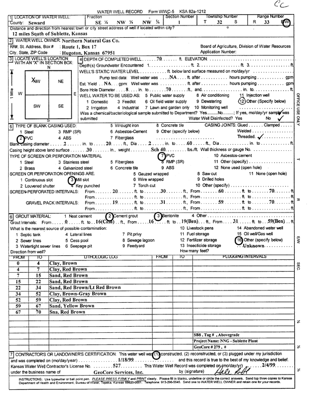
Specific Water Well Detail |
|
|
| Location Info | |||
| Owner: Northern Natural Gas Co. | Status: Constructed | ||
| Location: T32S, R33W, Sec. 1, SE NW NW | County: Seward | ||
| Directions: from Sublette: 12 mi S | |||
| Latitude: 37.2979462 | Longitude: -100.8651902 | Datum NAD 27 | |
| Latitude: 37.2979685 | Longitude: -100.865629 | Datum NAD 83 | |
| Longitude and latitude calculated by Survey from township-range-section-quarter calls. Only good to within the quarter call accuracy. | |||
| View well on interactive map | |||
| General Info | ||
| Well Depth: 70 ft. | Elevation: ft. | |
| Static Water Level: ft. | Est. Yield: gpm. | |
| Comp. Date: 18-Jan-1999 | Well Use: Other | |
| DWR Applic. #: | Other ID: | |
| Driller Info | ||
| Driller: GeoCore Services Inc. | License #: 527 | |
| Scanned Form | View scan |
|
Chemical Sample Submitted?:
Water Well disinfected?: | ||
| Casing Info | ||
| Casing Type:
Casing Joints: |
Diam: in. to ft | |
| Casing height above land surface: in
Casing Weight: lbs/ft Wall thickness or gauge no.: | ||
| Screen and Perforation Info | ||
| Screen Type: | Screen Openings: | |
| Screen-perforated intervals | From: ft to ft | |
| Gravel pack intervals | From: ft to ft | |
| Grout Info | ||
| Grout used: | From: to ft | |
| Source of Possible Contamination | ||
| Source: | ||
| Direction from well: | Distance: ft | |
| Lithologic Log
(Log data entered by KGS.) | ||
| From: 0 ft. to 4 ft. | clay, brown | |
| From: 4 ft. to 7 ft. | clay, red brown | |
| From: 7 ft. to 15 ft. | sand, red brown | |
| From: 15 ft. to 22 ft. | sand, red brown | |
| From: 22 ft. to 34 ft. | sand, red brown/lt red brown | |
| From: 34 ft. to 52 ft. | clay, brown-gray brown | |
| From: 52 ft. to 59 ft. | clay, red brown | |
| From: 59 ft. to 67 ft. | sand, yellow brown | |
| From: 67 ft. to 70 ft. | sand, red brown | |