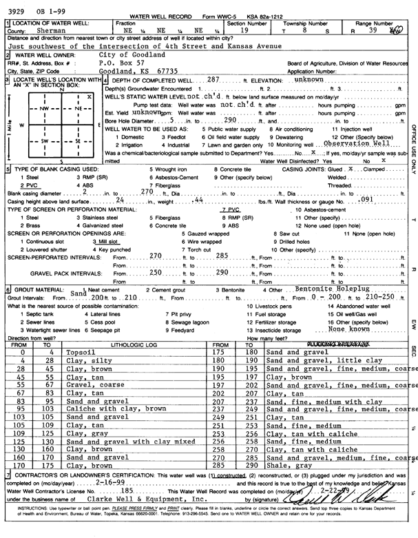
KGS Home Page Water Well Data base Specific Water Well Detail
Water Resources

Well T8S, R39W, Sec. 19, NE NE NE, Action: Constructed

Location Info
Owner: City of Goodland Status: Constructed
Location: T8S, R39W, Sec. 19, NE NE NE County: Sherman
Directions: SW of 4th St and Kansas Ave, Goodland
Latitude: 39.3503021 Longitude: -101.7081873 Datum NAD 27
Latitude: 39.3503018 Longitude: -101.7086373 Datum NAD 83
Longitude and latitude calculated by Survey from township-range-section-quarter calls. Only good to within the quarter call accuracy.
View well on interactive map This link will create a new window and display an interactive map of this well and its neighbors.
General Info
Well Depth: 287 ft. Elevation: ft.
Static Water Level: ft. Est. Yield: gpm.
Comp. Date: 16-Feb-1999 Well Use: Monitoring well/observation/piezometer
DWR Applic. #: Other ID: OB 1-99
Driller Info
Driller: Clarke Well and Equipment, Inc. License #: 185
Scanned Form
View form(s) on screen Download scan(s)
The download files contain one or more TIFF images compressed into a ZIP archive. Your browser may be already set up to decompress these files. The TIFFs are 300 dpi archival-quality scans of the WWC5 forms and can be viewed by software like Adobe PhotoShop.
Chemical Sample Submitted?:
Water Well disinfected?:
Casing Info
Casing Type:
Casing Joints:
Diam: in. to ft
Casing height above land surface: in
Casing Weight: lbs/ft
Wall thickness or gauge no.:
Screen and Perforation Info
Screen Type: Screen Openings:
Screen-perforated intervals From: ft to ft
Gravel pack intervals From: ft to ft
Grout Info
Grout used: From: to ft
Source of Possible Contamination
Source:
Direction from well: Distance: ft
Lithologic Log
(Log data entered by KGS.)
From: 0 ft. to 4 ft. Top soil
From: 4 ft. to 28 ft. Clay, silty
From: 28 ft. to 45 ft. Clay, brown
From: 45 ft. to 55 ft. Clay, tan
From: 55 ft. to 67 ft. Gravel, coarse
From: 67 ft. to 83 ft. Clay, tan
From: 83 ft. to 95 ft. Sand and gravel
From: 95 ft. to 103 ft. Caliche with clay, brown
From: 103 ft. to 105 ft. Sand and gravel
From: 105 ft. to 109 ft. Clay, tan
From: 109 ft. to 125 ft. Clay, gray
From: 125 ft. to 130 ft. Sand and gravel with clay mixed
From: 130 ft. to 160 ft. Clay, brown
From: 160 ft. to 170 ft. Sand and gravel
From: 170 ft. to 175 ft. Clay, brown
From: 175 ft. to 180 ft. Sand and gravel
From: 180 ft. to 190 ft. Sand and gravel, little clay
From: 190 ft. to 195 ft. Sand and gravel, fine, medium, coarse
From: 195 ft. to 197 ft. Clay, brown
From: 197 ft. to 202 ft. Sand and gravel, fine, medium, coarse
From: 202 ft. to 207 ft. Clay, tan
From: 207 ft. to 237 ft. Sand, fine, medium with clay
From: 237 ft. to 249 ft. Sand and gravel, fine, medium, coarse
From: 249 ft. to 251 ft. Clay, tan
From: 251 ft. to 253 ft. Sand, fine, medium
From: 253 ft. to 256 ft. Clay, tan with caliche
From: 256 ft. to 258 ft. Sand, fine, medium
From: 258 ft. to 270 ft. Clay, tan with caliche
From: 270 ft. to 285 ft. Sand and gravel, medium, fine, coarse
From: 285 ft. to 290 ft. Shale, gray

Kansas Geological Survey
Comments to webadmin@kgs.ku.edu
URL=http://www.kgs.ku.edu/Magellan/WaterWell/index.html
Display Programs Updated July 2, 2014
Data added continuously.