|
|
|
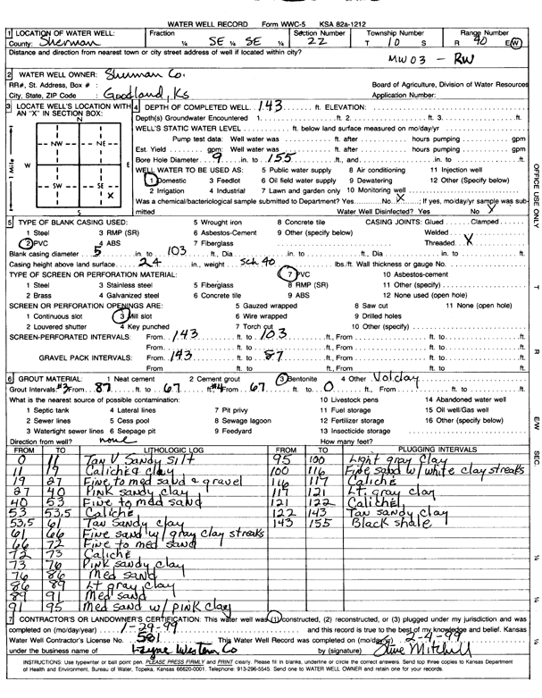
Specific Water Well Detail |
|
|
| Location Info | |||
| Owner: Sherman County | Status: Constructed | ||
| Location: T10S, R40W, Sec. 22, SE SE | County: Sherman | ||
| Directions: | |||
| Latitude: 39.1643985 | Longitude: -101.766018 | Datum NAD 27 | |
| Latitude: 39.1644018 | Longitude: -101.7664689 | Datum NAD 83 | |
| Longitude and latitude calculated by Survey from township-range-section-quarter calls. Only good to within the quarter call accuracy. | |||
| View well on interactive map | |||
| General Info | ||
| Well Depth: 143 ft. | Elevation: ft. | |
| Static Water Level: ft. | Est. Yield: gpm. | |
| Comp. Date: 29-Jan-1999 | Well Use: Monitoring well/observation/piezometer | |
| DWR Applic. #: | Other ID: MW 3 | |
| Driller Info | ||
| Driller: Layne Western Company | License #: 581 | |
| Scanned Form | View scan |
|
Chemical Sample Submitted?:
Water Well disinfected?: | ||
| Casing Info | ||
| Casing Type:
Casing Joints: |
Diam: in. to ft | |
| Casing height above land surface: in
Casing Weight: lbs/ft Wall thickness or gauge no.: | ||
| Screen and Perforation Info | ||
| Screen Type: | Screen Openings: | |
| Screen-perforated intervals | From: ft to ft | |
| Gravel pack intervals | From: ft to ft | |
| Grout Info | ||
| Grout used: | From: to ft | |
| Source of Possible Contamination | ||
| Source: | ||
| Direction from well: | Distance: ft | |
| Lithologic Log
(Log data entered by KGS.) | ||
| From: 0 ft. to 11 ft. | Tan very sandy silt | |
| From: 11 ft. to 19 ft. | Caliche and clay | |
| From: 19 ft. to 27 ft. | Fine to medium sand and gravel | |
| From: 27 ft. to 40 ft. | Pink sandy clay | |
| From: 40 ft. to 53 ft. | Fine to medium sand | |
| From: 53 ft. to 53.5 ft. | Caliche | |
| From: 53.5 ft. to 61 ft. | Tan sandy clay | |
| From: 61 ft. to 66 ft. | Fine sand with gray clay streaks | |
| From: 66 ft. to 72 ft. | Fine to medium sand | |
| From: 72 ft. to 73 ft. | Caliche | |
| From: 73 ft. to 76 ft. | Pink sandy clay | |
| From: 76 ft. to 86 ft. | Medium sand | |
| From: 86 ft. to 89 ft. | Light gray sand | |
| From: 89 ft. to 91 ft. | Medium sand | |
| From: 91 ft. to 95 ft. | Medium sand with pink clay | |
| From: 95 ft. to 100 ft. | Light gray clay | |
| From: 100 ft. to 116 ft. | Fine sand with white clay streaks | |
| From: 116 ft. to 117 ft. | Caliche | |
| From: 117 ft. to 121 ft. | Light gray clay | |
| From: 121 ft. to 122 ft. | Caliche | |
| From: 122 ft. to 143 ft. | Tan sandy clay | |
| From: 143 ft. to 155 ft. | Black shale | |