|
|
|
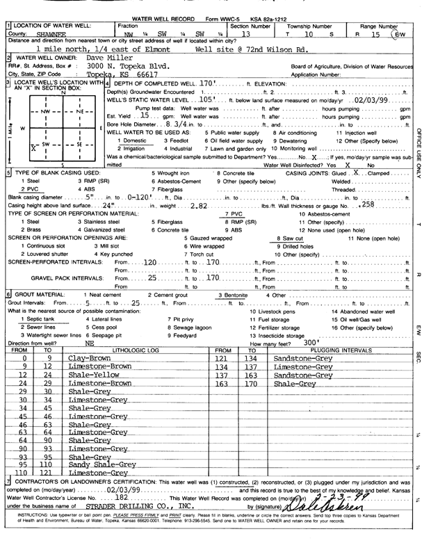
Specific Water Well Detail |
|
|
| Location Info | |||
| Owner: Miller, Dave | Status: Constructed | ||
| Location: T10S, R15E, Sec. 13, NW SW SW | County: Shawnee | ||
| Directions: 72nd Wilson Rd - from Elmont: 1 mi N, .25 mi E | |||
| Latitude: 39.1756067 | Longitude: -95.6996529 | Datum NAD 27 | |
| Latitude: 39.175605 | Longitude: -95.6999127 | Datum NAD 83 | |
| Longitude and latitude calculated by Survey from township-range-section-quarter calls. Only good to within the quarter call accuracy. | |||
| View well on interactive map | |||
| General Info | ||
| Well Depth: 170 ft. | Elevation: ft. | |
| Static Water Level: 105 ft. | Est. Yield: 15 gpm. | |
| Comp. Date: 03-Feb-1999 | Well Use: Domestic | |
| DWR Applic. #: | Other ID: | |
| Driller Info | ||
| Driller: Strader Drilling Co., Inc. | License #: 182 | |
| Scanned Form | View scan |
|
Chemical Sample Submitted?:
Water Well disinfected?: | ||
| Casing Info | ||
| Casing Type:
Casing Joints: |
Diam: in. to ft | |
| Casing height above land surface: in
Casing Weight: lbs/ft Wall thickness or gauge no.: | ||
| Screen and Perforation Info | ||
| Screen Type: | Screen Openings: | |
| Screen-perforated intervals | From: ft to ft | |
| Gravel pack intervals | From: ft to ft | |
| Grout Info | ||
| Grout used: | From: to ft | |
| Source of Possible Contamination | ||
| Source: | ||
| Direction from well: | Distance: ft | |
| Lithologic Log
(Log data entered by KGS.) | ||
| From: 0 ft. to 9 ft. | clay, brown | |
| From: 9 ft. to 12 ft. | limestone, brown | |
| From: 12 ft. to 24 ft. | shale, yellow | |
| From: 24 ft. to 29 ft. | limestone, brown | |
| From: 29 ft. to 30 ft. | shale, gray | |
| From: 30 ft. to 34 ft. | limestone, gray | |
| From: 34 ft. to 45 ft. | shale, gray | |
| From: 45 ft. to 46 ft. | limestone, gray | |
| From: 46 ft. to 63 ft. | shale, gray | |
| From: 63 ft. to 64 ft. | limestone, gray | |
| From: 64 ft. to 90 ft. | shale, gray | |
| From: 90 ft. to 93 ft. | limestone, gray | |
| From: 93 ft. to 95 ft. | shale, gray | |
| From: 95 ft. to 110 ft. | sandy shale, gray | |
| From: 110 ft. to 121 ft. | limestone, gray | |
| From: 121 ft. to 134 ft. | sandstone, gray | |
| From: 134 ft. to 137 ft. | limestone, gray | |
| From: 137 ft. to 163 ft. | sandstone, gray | |
| From: 163 ft. to 170 ft. | shale, gray | |