|
|
|
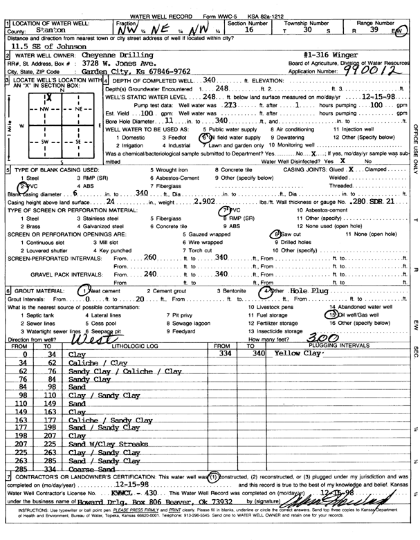
Specific Water Well Detail |
|
|
| Location Info | |||
| Owner: Cheyenne Drilling | Status: Constructed | ||
| Location: T30S, R39W, Sec. 16, NW NE NW | County: Stanton | ||
| Directions: from Johnson, 11.5 mi SE | |||
| Latitude: 37.445591 | Longitude: -101.5926364 | Datum NAD 27 | |
| Latitude: 37.4456119 | Longitude: -101.5930813 | Datum NAD 83 | |
| Longitude and latitude calculated by Survey from township-range-section-quarter calls. Only good to within the quarter call accuracy. | |||
| View well on interactive map | |||
| General Info | ||
| Well Depth: 340 ft. | Elevation: ft. | |
| Static Water Level: 248 ft. | Est. Yield: 100 gpm. | |
| Comp. Date: 15-Dec-1998 | Well Use: Oil Field Water Supply | |
| DWR Applic. #: 990012 | Other ID: Winger 1-316 | |
| Links | |
| No Wizard information available. | |
| View info from WIMAS Water Right Data base... | |
| Driller Info | ||
| Driller: Howard Drilling Company AG, LLC | License #: 430 | |
| Scanned Form | View scan |
|
Chemical Sample Submitted?:
Water Well disinfected?: | ||
| Casing Info | ||
| Casing Type:
Casing Joints: |
Diam: in. to ft | |
| Casing height above land surface: in
Casing Weight: lbs/ft Wall thickness or gauge no.: | ||
| Screen and Perforation Info | ||
| Screen Type: | Screen Openings: | |
| Screen-perforated intervals | From: ft to ft | |
| Gravel pack intervals | From: ft to ft | |
| Grout Info | ||
| Grout used: | From: to ft | |
| Source of Possible Contamination | ||
| Source: | ||
| Direction from well: | Distance: ft | |
| Lithologic Log
(Log data entered by KGS.) | ||
| From: 0 ft. to 34 ft. | clay | |
| From: 34 ft. to 62 ft. | caliche / clay | |
| From: 62 ft. to 76 ft. | sandy clay / caliche / clay | |
| From: 76 ft. to 84 ft. | sandy clay | |
| From: 84 ft. to 98 ft. | sand | |
| From: 98 ft. to 110 ft. | clay / sandy clay | |
| From: 110 ft. to 149 ft. | sand | |
| From: 149 ft. to 163 ft. | clay | |
| From: 163 ft. to 177 ft. | caliche / sandy clay | |
| From: 177 ft. to 198 ft. | sand / sandy clay | |
| From: 198 ft. to 207 ft. | clay | |
| From: 207 ft. to 225 ft. | sand with clay streaks | |
| From: 225 ft. to 263 ft. | clay / sandy clay | |
| From: 263 ft. to 285 ft. | sand / sandy clay | |
| From: 285 ft. to 334 ft. | coarse sand | |
| From: 334 ft. to 340 ft. | yellow clay | |