|
|
|
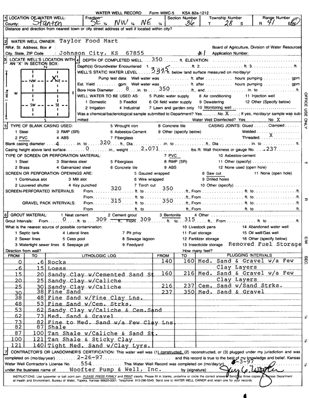
Specific Water Well Detail |
|
|
| Location Info | |||
| Owner: Taylor Food Mart | Status: Constructed | ||
| Location: T28S, R41W, Sec. 36, SE NW NE | County: Stanton | ||
| Directions: | |||
| Latitude: 37.5746578 | Longitude: -101.7488148 | Datum NAD 27 | |
| Latitude: 37.5746746 | Longitude: -101.749264 | Datum NAD 83 | |
| Longitude and latitude calculated by Survey from township-range-section-quarter calls. Only good to within the quarter call accuracy. | |||
| View well on interactive map | |||
| General Info | ||
| Well Depth: 350 ft. | Elevation: ft. | |
| Static Water Level: 337.5 ft. | Est. Yield: gpm. | |
| Comp. Date: 26-Feb-1997 | Well Use: Monitoring well/observation/piezometer | |
| DWR Applic. #: | Other ID: MW 1 | |
| Driller Info | ||
| Driller: Woofter Pump & Well, Inc. | License #: 554 | |
| Scanned Form | View scan |
|
Chemical Sample Submitted?:
Water Well disinfected?: | ||
| Casing Info | ||
| Casing Type:
Casing Joints: |
Diam: in. to ft | |
| Casing height above land surface: in
Casing Weight: lbs/ft Wall thickness or gauge no.: | ||
| Screen and Perforation Info | ||
| Screen Type: | Screen Openings: | |
| Screen-perforated intervals | From: ft to ft | |
| Gravel pack intervals | From: ft to ft | |
| Grout Info | ||
| Grout used: | From: to ft | |
| Source of Possible Contamination | ||
| Source: | ||
| Direction from well: | Distance: ft | |
| Lithologic Log
(Log data entered by KGS.) | ||
| From: 0 ft. to .6 ft. | rocks | |
| From: .6 ft. to 15 ft. | loess | |
| From: 15 ft. to 20 ft. | sandy clay with cemented sand streak | |
| From: 20 ft. to 25 ft. | sandy clay with caliche | |
| From: 25 ft. to 30 ft. | sandy clay with caliche | |
| From: 30 ft. to 38 ft. | fine sand | |
| From: 38 ft. to 48 ft. | fine sand with fine clay lens | |
| From: 48 ft. to 53 ft. | fine sand with cemented streak | |
| From: 53 ft. to 62 ft. | sandy clay with caliche and cemented sand | |
| From: 62 ft. to 73 ft. | medium sand and gravel | |
| From: 73 ft. to 82 ft. | fine to medium sand with a few clay lens | |
| From: 82 ft. to 87 ft. | shale | |
| From: 87 ft. to 100 ft. | tan shale with caliche and sand streak | |
| From: 100 ft. to 121 ft. | tan shale and sticky clay | |
| From: 121 ft. to 140 ft. | tight medium sand with clay layers | |
| From: 140 ft. to 160 ft. | medium sand and gravel with a few clay layers | |
| From: 160 ft. to 216 ft. | medium sand and gravel with a few clay layers | |
| From: 216 ft. to 237 ft. | cemented sand with sand streaks | |
| From: 237 ft. to 350 ft. | medium sand and gravel | |