|
|
|
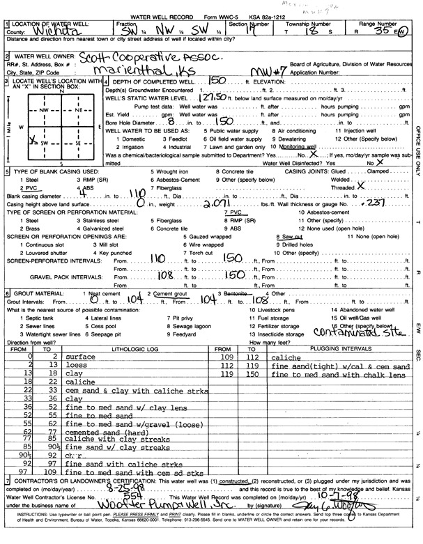
Specific Water Well Detail |
|
|
| Location Info | |||
| Owner: Scott Coop Assoc. | Status: Constructed | ||
| Location: T18S, R35W, Sec. 17, C NW SW | County: Wichita | ||
| Directions: | |||
| Latitude: 38.4872416 | Longitude: -101.2173829 | Datum NAD 27 | |
| Latitude: 38.4872619 | Longitude: -101.2178169 | Datum NAD 83 | |
| Longitude and latitude calculated by Survey from township-range-section-quarter calls. Only good to within the quarter call accuracy. | |||
| View well on interactive map | |||
| General Info | ||
| Well Depth: 150 ft. | Elevation: ft. | |
| Static Water Level: 127.5 ft. | Est. Yield: gpm. | |
| Comp. Date: 25-Aug-1998 | Well Use: Monitoring well/observation/piezometer | |
| DWR Applic. #: | Other ID: MW 7 | |
| Driller Info | ||
| Driller: Woofter Pump and Well Inc. | License #: 554 | |
| Scanned Form | View scan |
|
Chemical Sample Submitted?:
Water Well disinfected?: | ||
| Casing Info | ||
| Casing Type:
Casing Joints: |
Diam: in. to ft | |
| Casing height above land surface: in
Casing Weight: lbs/ft Wall thickness or gauge no.: | ||
| Screen and Perforation Info | ||
| Screen Type: | Screen Openings: | |
| Screen-perforated intervals | From: ft to ft | |
| Gravel pack intervals | From: ft to ft | |
| Grout Info | ||
| Grout used: | From: to ft | |
| Source of Possible Contamination | ||
| Source: | ||
| Direction from well: | Distance: ft | |
| Lithologic Log
(Log data entered by KGS.) | ||
| From: 0 ft. to 2 ft. | Surface | |
| From: 2 ft. to 13 ft. | Loess | |
| From: 13 ft. to 18 ft. | Clay | |
| From: 18 ft. to 22 ft. | Caliche | |
| From: 22 ft. to 33 ft. | Cemented sand and clay with caliche streaks | |
| From: 33 ft. to 36 ft. | Clay | |
| From: 36 ft. to 52 ft. | Fine to medium sand with clay lens | |
| From: 52 ft. to 55 ft. | Fine to medium sand | |
| From: 55 ft. to 62 ft. | Fine to medium sand with gravel, loose | |
| From: 62 ft. to 77 ft. | Cemented sand, hard | |
| From: 77 ft. to 85 ft. | Caliche with clay streaks | |
| From: 85 ft. to 90.5 ft. | Fine sand with clay streaks | |
| From: 90.5 ft. to 92 ft. | Chert | |
| From: 92 ft. to 97 ft. | Fine sand with caliche streaks | |
| From: 97 ft. to 109 ft. | Fine to medium sand with cemented sand streaks | |
| From: 109 ft. to 112 ft. | Caliche | |
| From: 112 ft. to 119 ft. | Fine sand, tight, with caliche and cemented sand | |
| From: 119 ft. to 150 ft. | Fine to medium sand with chalk lens | |