|
|
|
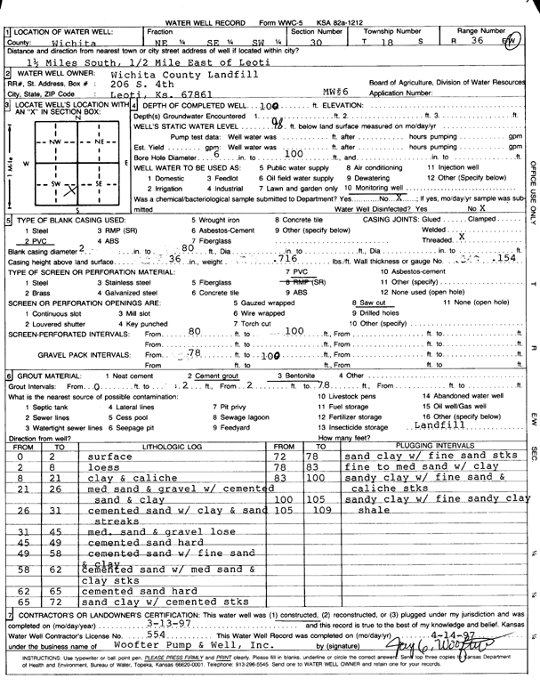
Specific Water Well Detail |
|
|
| Location Info | |||
| Owner: Wichita County Landfill | Status: Constructed | ||
| Location: T18S, R36W, Sec. 30, NE SE SW | County: Wichita | ||
| Directions: from Leoti, 1.5 mi S and 0.5 mi E | |||
| Latitude: 38.4551514 | Longitude: -101.3405929 | Datum NAD 27 | |
| Latitude: 38.4551706 | Longitude: -101.3410308 | Datum NAD 83 | |
| Longitude and latitude calculated by Survey from township-range-section-quarter calls. Only good to within the quarter call accuracy. | |||
| View well on interactive map | |||
| General Info | ||
| Well Depth: 109 ft. | Elevation: ft. | |
| Static Water Level: 98 ft. | Est. Yield: gpm. | |
| Comp. Date: 13-Mar-1997 | Well Use: Monitoring well/observation/piezometer | |
| DWR Applic. #: | Other ID: MW 6 | |
| Driller Info | ||
| Driller: Woofter Pump and Well Inc | License #: 554 | |
| Scanned Form | View scan |
|
Chemical Sample Submitted?:
Water Well disinfected?: | ||
| Casing Info | ||
| Casing Type:
Casing Joints: |
Diam: in. to ft | |
| Casing height above land surface: in
Casing Weight: lbs/ft Wall thickness or gauge no.: | ||
| Screen and Perforation Info | ||
| Screen Type: | Screen Openings: | |
| Screen-perforated intervals | From: ft to ft | |
| Gravel pack intervals | From: ft to ft | |
| Grout Info | ||
| Grout used: | From: to ft | |
| Source of Possible Contamination | ||
| Source: | ||
| Direction from well: | Distance: ft | |
| Lithologic Log
(Log data entered by KGS.) | ||
| From: 0 ft. to 2 ft. | Surface | |
| From: 2 ft. to 8 ft. | Loess | |
| From: 8 ft. to 21 ft. | Clay and caliche | |
| From: 21 ft. to 26 ft. | Medium sand and gravel with cemented sand and clay | |
| From: 26 ft. to 31 ft. | Cemented sand with clay and sand streaks | |
| From: 31 ft. to 45 ft. | Medium sand and gravel, loose | |
| From: 45 ft. to 49 ft. | Cemented sand, hard | |
| From: 49 ft. to 58 ft. | Cemented sand with fine sand and clay | |
| From: 58 ft. to 62 ft. | Cemented sand with medium sand and clay streaks | |
| From: 62 ft. to 65 ft. | Cemented sand, hard | |
| From: 65 ft. to 72 ft. | Sand clay with cemented streaks | |
| From: 72 ft. to 78 ft. | Sand clay with fine sand streaks | |
| From: 78 ft. to 83 ft. | Fine to medium sand with clay | |
| From: 83 ft. to 100 ft. | Sandy clay with fine sand and caliche streaks | |
| From: 100 ft. to 105 ft. | Sandy clay with fine sandy clay | |
| From: 105 ft. to 109 ft. | Shale | |