|
|
|
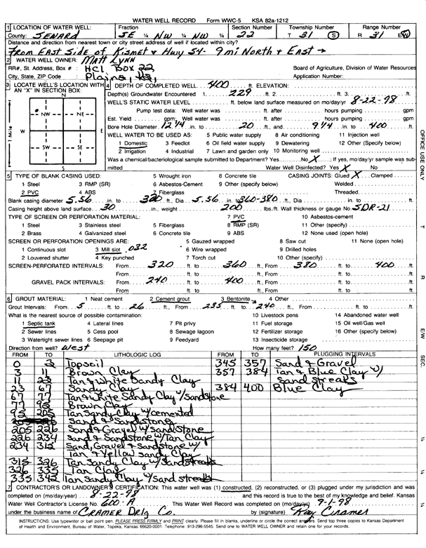
Specific Water Well Detail |
|
|
| Location Info | |||
| Owner: Lynn, Matt | Status: Constructed | ||
| Location: T31S, R31W, Sec. 22, SE NW NW | County: Seward | ||
| Directions: from E side of Kimset and Hwy 54: 9 miles N and E | |||
| Latitude: 37.3415214 | Longitude: -100.6853854 | Datum NAD 27 | |
| Latitude: 37.3415432 | Longitude: -100.6858189 | Datum NAD 83 | |
| Longitude and latitude calculated by Survey from township-range-section-quarter calls. Only good to within the quarter call accuracy. | |||
| View well on interactive map | |||
| General Info | ||
| Well Depth: 400 ft. | Elevation: ft. | |
| Static Water Level: 229 ft. | Est. Yield: gpm. | |
| Comp. Date: 22-Aug-1998 | Well Use: Domestic | |
| DWR Applic. #: | Other ID: | |
| Driller Info | ||
| Driller: Cramer Drilling Co. | License #: 600 | |
| Scanned Form | View scan |
|
Chemical Sample Submitted?:
Water Well disinfected?: | ||
| Casing Info | ||
| Casing Type:
Casing Joints: |
Diam: in. to ft | |
| Casing height above land surface: in
Casing Weight: lbs/ft Wall thickness or gauge no.: | ||
| Screen and Perforation Info | ||
| Screen Type: | Screen Openings: | |
| Screen-perforated intervals | From: ft to ft | |
| Gravel pack intervals | From: ft to ft | |
| Grout Info | ||
| Grout used: | From: to ft | |
| Source of Possible Contamination | ||
| Source: | ||
| Direction from well: | Distance: ft | |
| Lithologic Log
(Log data entered by KGS.) | ||
| From: 0 ft. to 3 ft. | topsoil | |
| From: 3 ft. to 11 ft. | brown clay | |
| From: 11 ft. to 23 ft. | tan and white sandy clay | |
| From: 23 ft. to 67 ft. | sandy clay | |
| From: 67 ft. to 77 ft. | tan and white sandy clay with sandstone | |
| From: 77 ft. to 95 ft. | brown clay | |
| From: 95 ft. to 205 ft. | tan sandy clay with cemented sand and sandstone | |
| From: 205 ft. to 226 ft. | sand and gravel with sandstone | |
| From: 226 ft. to 234 ft. | sand and sandstone with tan clay | |
| From: 234 ft. to 312 ft. | sand, gravel and sandstone with tan and yellow sandy clay | |
| From: 315 ft. to 326 ft. | tan sandy clay with sand streaks | |
| From: 326 ft. to 335 ft. | tan clay | |
| From: 335 ft. to 342 ft. | tan sandy clay with sand streaks | |
| From: 342 ft. to 357 ft. | sand and gravel | |
| From: 357 ft. to 384 ft. | tan and blue clay with sand streaks | |
| From: 384 ft. to 400 ft. | blue clay | |